
Hudson Valley winter outlook 2025-26
Come one, come all, and get the inside scoop on how snowy the Hudson Valley’s winter could be!

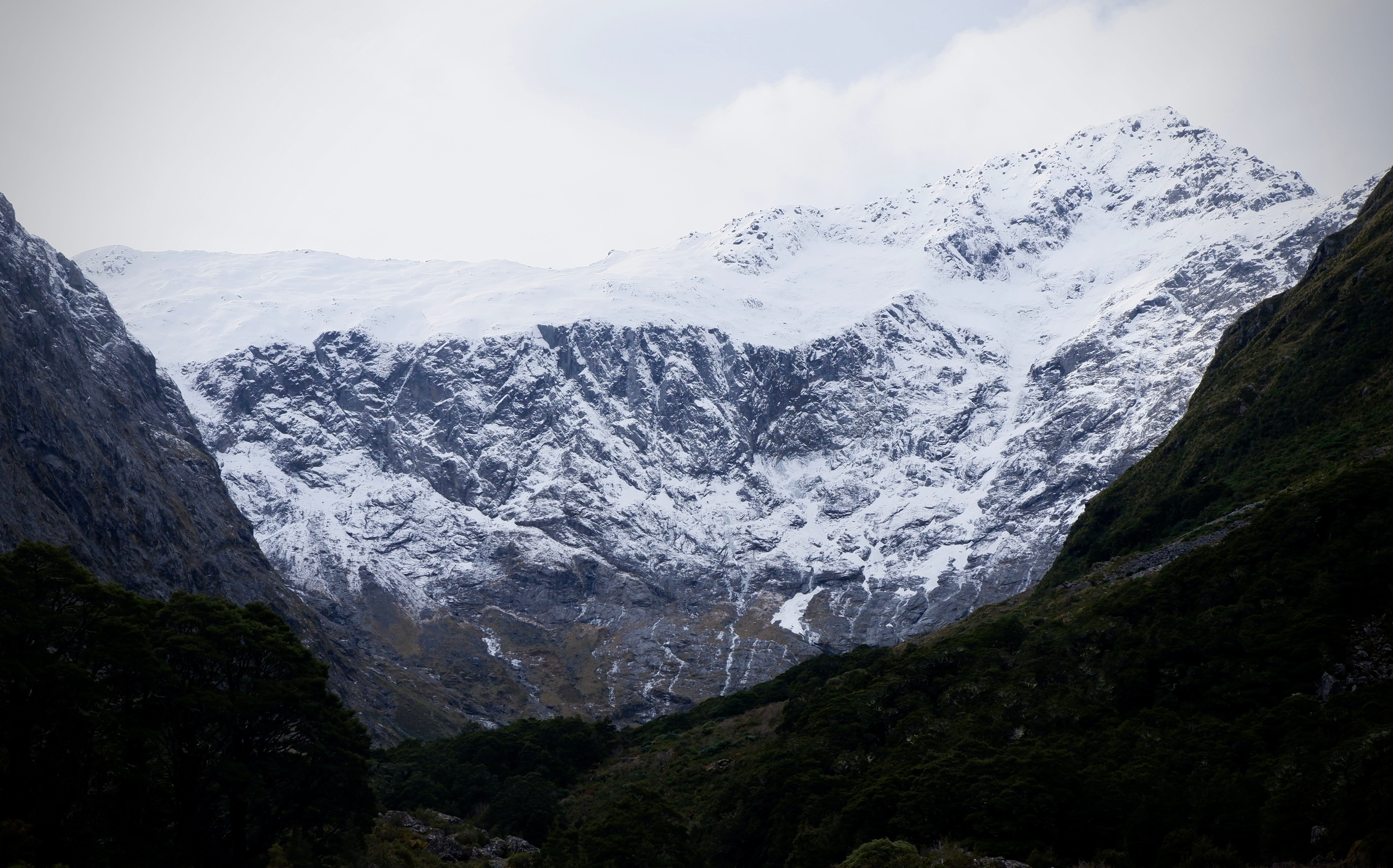
It’s hard to believe, but winter is just weeks away from arriving in the Hudson Valley.
But let’s face it: winters aren’t quite what they used to be around here.
It’s not to say that a polar vortex-filled winter like 2014-15, a blizzard-filled one like 1995-96, or the ultra harsh winters of the late 1970s won’t happen ever again, but it is getting harder to have one like those, the numbers tell us.
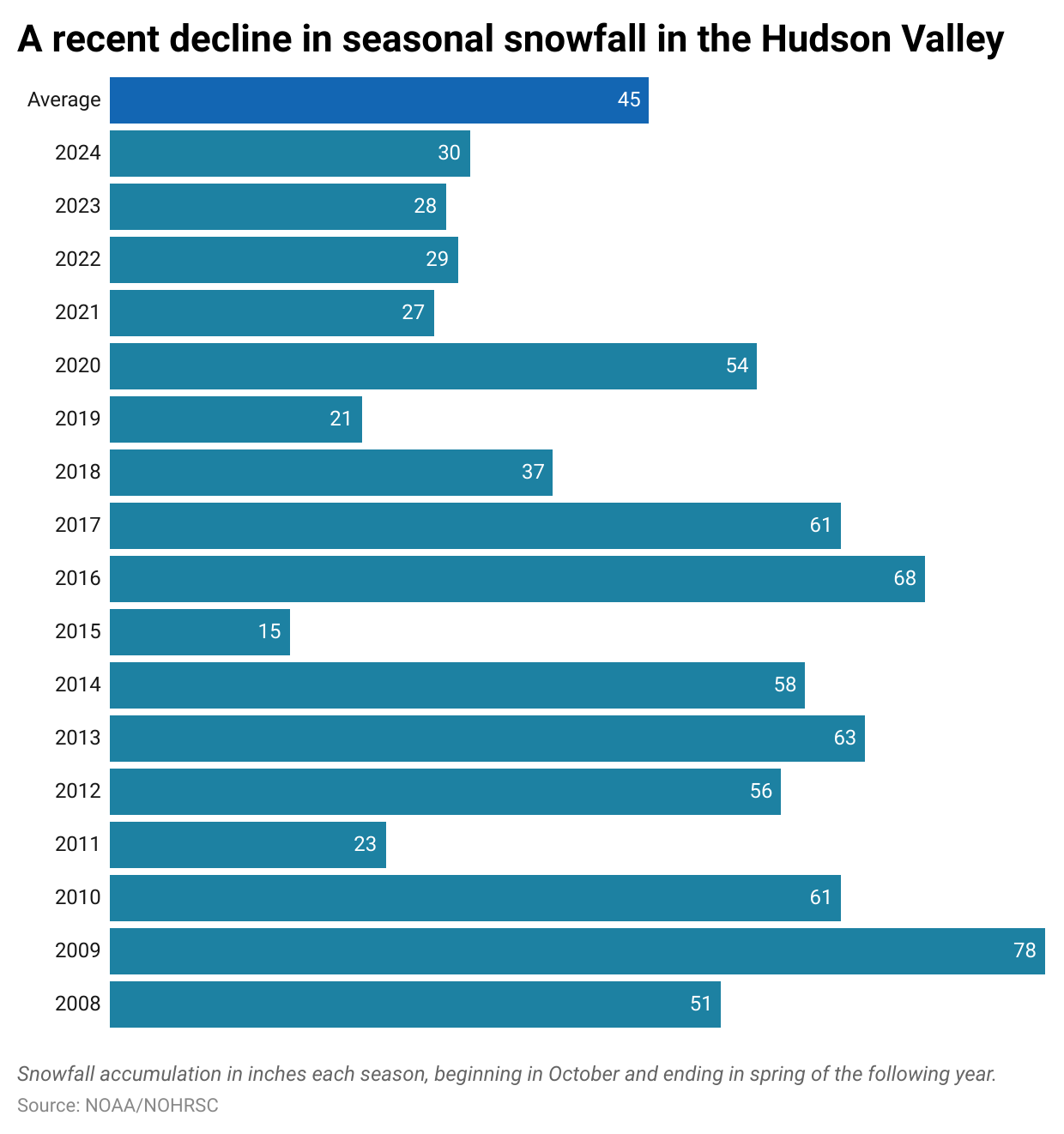
Only one winter out of the last seven has had above-average snowfall across the Hudson Valley.
Despite what the Farmer’s Almanac may say every year about how cold and snowy the winter ahead will be, the trend is not our friend.
But there are reasons to believe that the winter ahead will have some similarities with last winter, which wasn’t a total bust, despite having slightly below normal seasonal snowfall.

Here are my main takeaways for the season ahead:
Unlikely to break records for snow. Over the past five winters, there’s been about 20 to 40 percent less snow than normal in the Hudson Valley — and it seems unlikely that the winter ahead will reverse that trend. I think snowfall will most likely be near or slightly below the seasonal average, which is around 40 inches.
Confidence: moderate.
Big temperature swings. While a record-cold winter is unlikely, several sharp cold snaps are likely through the season as the polar vortex may sit closer to the United States than normal, similar to last winter.
Confidence: moderate-to-high.
More mixed precipitation events. There may be fewer coastal storms than normal this winter, with more systems tracking in from the west. These storms tend to draw up warmer air and bring mixed precipitation, including ice, to the Hudson Valley.
Confidence: moderate-to-high.
Here’s the approximate chance of experiencing above-average snowfall around the Hudson Valley during the months ahead, based on historical years with similar climate patterns.
November: 20 to 30 percent (low)
December: 40 to 50 percent (medium)
January: 50 to 60 percent (medium)
February: 20 to 30 percent (low)
March: 60 to 70 percent (medium-high)
We’ll dive into the science behind these headlines soon, but first, let’s look at how the winter climate has changed in the Hudson Valley over the decades.
Winter is the fastest warming season
Winter is the fastest warming season in the Hudson Valley and it’s tough to argue with temperatures. Quite simply, the more time spent above 32 degrees, the harder it is for wintry precipitation to fall.
Here’s a striking statistic: over the past decade, there have been about 17 fewer days with lows below 32°F per winter than during the 1961–1990 period.
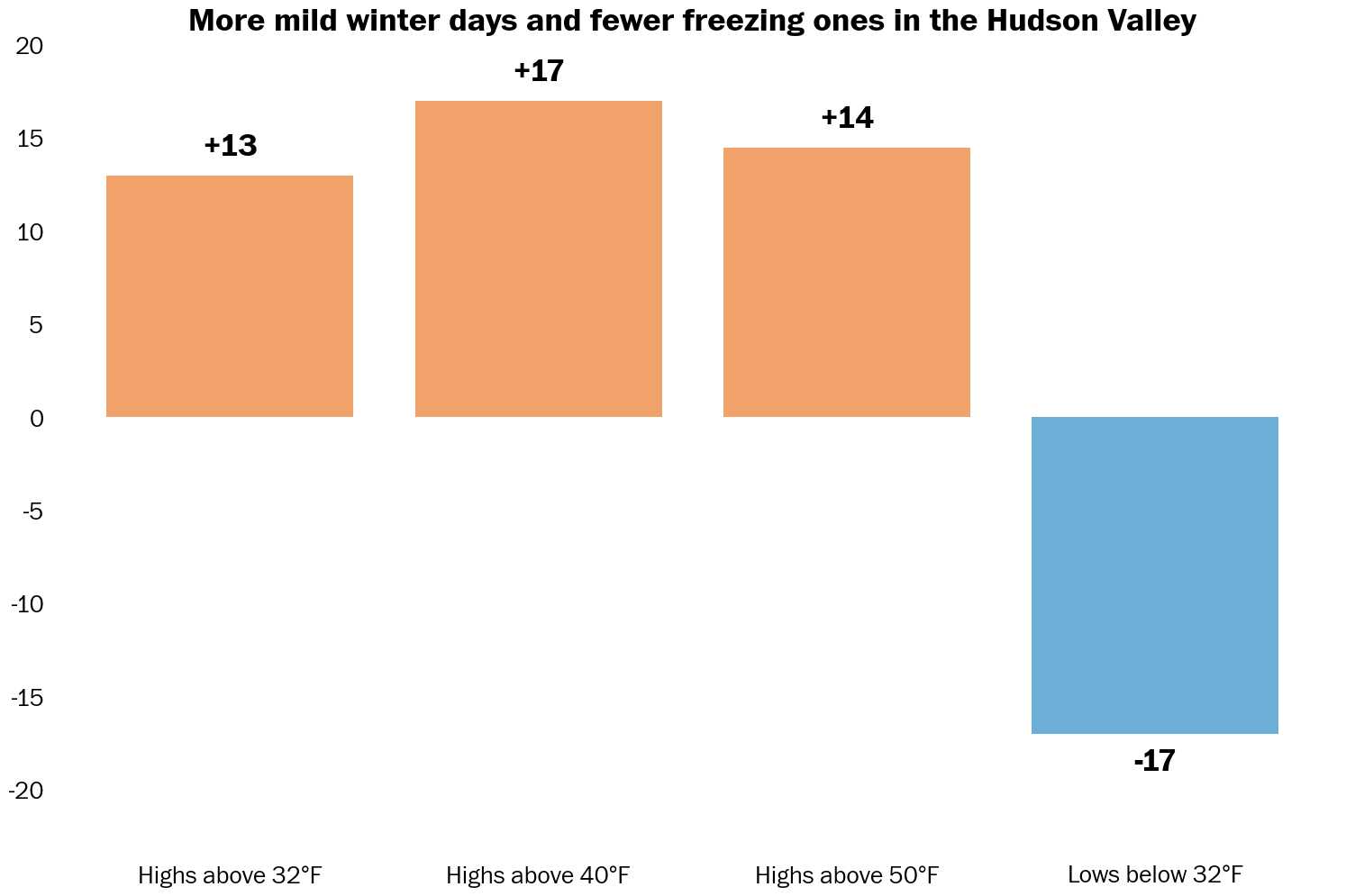
During the day, winter high temperatures are more routinely reaching 40 or 50 degrees from December through March.
But how are temperatures changing within the season? Let’s break that down by week:
Every week from December through March has warmed over the past decade. If you look closely, you’ll see that December has had some of the steepest upward trends — it’s the fastest warming month of the year in the Hudson Valley.
Compared to other winter months, changes during March are a bit less stark. Perhaps that’s a sign that winter is holding on a little longer at the end.
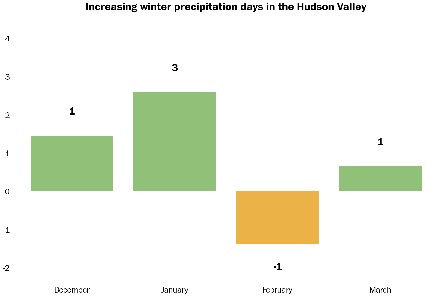
A trend toward more precipitation days has accompanied the warming trend. This is unsurprising, as a warmer atmosphere can hold more water vapor.
January has seen the biggest shift, with three more precipitation days, on average. This means there’s several more opportunities for snow, ice, or rain during the season.
Reading the winter tea leaves
“If you can’t predict the weather in a week, why should I believe your winter outlook?”
Fair question.
Long-range outlooks are distinctly different from short-term forecasts. Think of it like planning a road trip. You might not know the exact traffic you’ll hit on any given day, but you can be pretty confident which routes tend to be busier or quieter over time. In the same way, seasonal outlooks reveal broader climate tendencies, not day-to-day specifics. But they aren’t as accurate as daily forecasts. Instead, they’re correct about 40 to 60 percent of the time, which is important to bear in mind as you read on.
Guiding those climate tendencies this winter are two patterns in the Pacific Ocean: La Niña near the equator and a marine heat wave in the north.
Although La Niña occurs thousands of miles away from the United States, it has an important influence on weather patterns across the country.
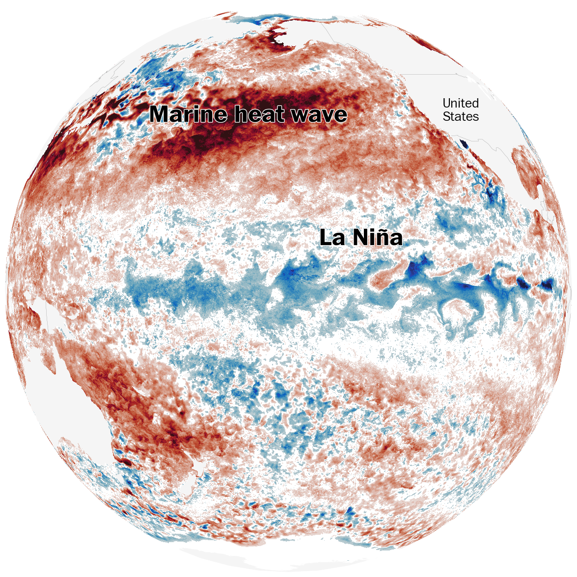
During winter, fast-flowing ribbons of air — called jet streams — race tens of thousands feet above the ground, steering storms around the planet.
La Niña’s cool Pacific Ocean waters tend to influence a weaker southern jet stream, bringing drier, warmer and less snowy conditions to the southern United States.
The southern jet stream is the one that’s important to coastal storms called nor’easters — the ones that can bring feet of snow to the Mid-Atlantic, Northeast and New England. If the southern jet is weak, there is a lower chance for such storms.
At the same time, the northern jet stream tends to be stronger, flowing from Canada across the northern tier of states during La Niña. This year, that jet stream may gain yet more strength because of the marine heat wave spanning the North Pacific.
This jet stream can tow fast-moving clipper systems that bring a few inches of snow and are gone in a flash. It can also cause storms to track in from the west, dragging in milder air and mixed precipitation, including ice.
The Hudson Valley will probably be caught in the middle of these two jet stream anomalies, amid a temperature battleground, creating more uncertainty as to how much snow may fall.
But odds favor less snow than normal in the Northeast, according to models that predict seasonal snowfall.
However, La Niña may rapidly fade during early 2026, bringing a rising chance for changing weather patterns at the tail end of winter, perhaps elevating the potential for a big late season storm.
But that doesn’t mean the season comes without hope. Mother Nature has tricks up her sleeve.
The behavior of the polar vortex — a swirling ring of frigid, stormy air high above the North Pole during winter — is something that forecasters will be carefully watching.
Occasionally, shifts in winds or pressure patterns can disrupt the vortex, causing it to warm dramatically and trigger a chain reaction through the atmosphere. This can sometimes push Arctic air southward into the midlatitudes, where most people live.
However, such events are difficult to predict beyond a few weeks out.
This year, a rare version of this phenomenon occurred above Antarctica at the end of the Southern Hemisphere winter, transforming a once-perfectly circular polar vortex into a lopsided, squished shape, influencing weather patterns down under.
Whether the Northern Hemisphere will experience a similar event this winter is unknown. Snow day enthusiasts can only hope it does, offering a brief reprieve from declining seasonal snowfall.
Final thoughts
I don’t think this winter will be a total bust, but the chances for a blockbuster season are modest.
Snow-wise, the trend just hasn’t been the Hudson Valley’s since about 2018.
But as La Niña fades early in 2026, the risk for a late season winter storm may rise.
It won’t be long before you see me write “I’m monitoring the potential for…” and that’s when you’ll know that winter is truly is arriving in the Hudson Valley.
Fingers crossed for some snow day magic 🤞
Sigh