
A summer of sunshine or downpours?
Summer 2025 outlook for the Hudson Valley reveals whether you can expect drought and extreme heat or downpours and high humidity this year.


Happy almost meteorological summer! Summer, according to meteorological calendars, starts on Sunday, June 1. This year, the first day of the meteorological season certainly won’t feel like summer.
The more traditional start date is the summer solstice, arriving on June 20 this year.
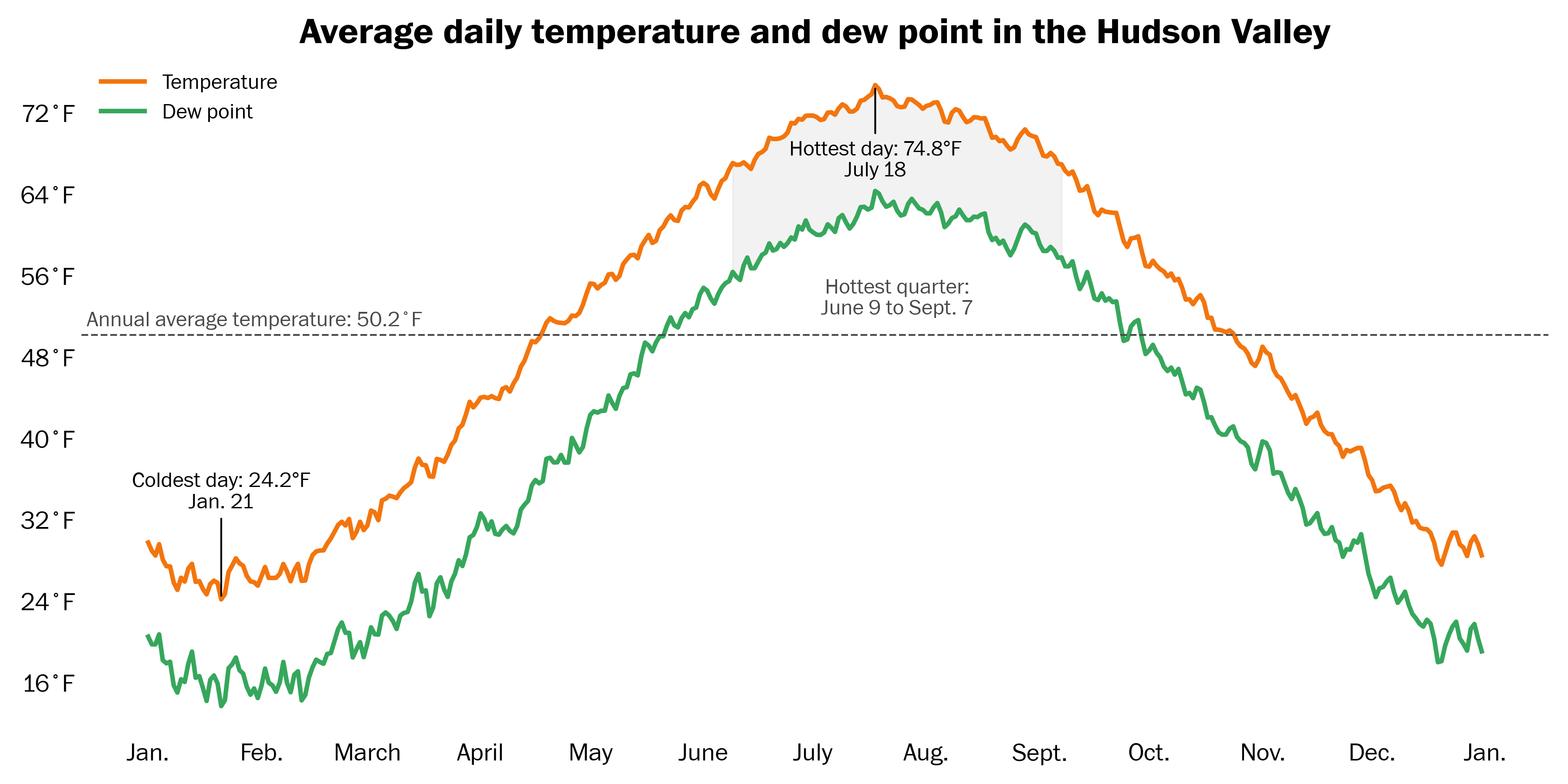
Then there’s Mother Nature’s date — based on the average warmest quarter (91-day period) of the year. In the Hudson Valley, that runs from June 9 to Sept. 7. The most humid quarter of the year lags slightly behind and runs from June 12 to Sept. 10.
Regardless of the date you prefer, you’re probably wondering: when will the weather start acting like summer? And what will the season ahead be like?
Before looking forward, let’s take a quick look back at the last three summers in the Hudson Valley:
Summer 2022: big drought, exceedingly hot
Summer 2023: big wet, average temperatures
Summer 2024: average rainfall, well above average temperatures
Remarkably, there’s only been one cooler than average Hudson Valley summer in the last decade. Things really are getting warmer around here.
Using history as a rough guide, it seems quite unlikely we’re headed for a cool summer. Of the last six summers, two have had above average rainfall — but another wet one might be added this year.
Based on a variety of factors, here’s what I’m seeing for the season ahead:
A summer with average or above average rainfall looks more likely than one with drought
Above average summer temperatures, especially at night, look much more likely than cooler than average temperatures
The tropics could be quite stormy, possibly as early as June, with plumes of moisture and humid air blowing into the Northeast — including the Hudson Valley, linked to a marine heat wave near Florida
To come up with these bullet points, I consider gobs of data, ranging from computer models to researching historical years that have climatic similarities with the present — called analogs.
Analog years
This summer, analog years include 2021, 2017, 2013, 2011, and 2008.
Summer 2021 is probably the strongest analog of the bunch. It’s the most recent and leaned toward La Niña in the tropical Pacific, similar to this year.
Learn more about La Niña

That summer started warm and dry and was followed by deluges in July and August. The summer of 2017 started off pretty normal, but also got wetter in July and August.
Summer 2013 had deluges throughout, as did 2011.
I’m sensing a theme.
This illustrates the potential for the summer ahead to get stuck in a pattern of downpours, humidity, and particularly warm nighttime temperatures.
Model outlook
In this section, I’ll share maps showing data from a blend of the world’s best seasonal climate models.
Even the best models are imperfect, having an accuracy rate of 40 to 60 percent on average — much lower than a short-term weather forecast, which is accurate approximately nine times out of 10.
Every month, around 10 forecasting centers globally contribute their seasonal outlook to an international consortium of climate data providers called Copernicus. I download this data and turn it into colorful maps.
Here’s what it shows.
Temperatures — warm to hot summer likely
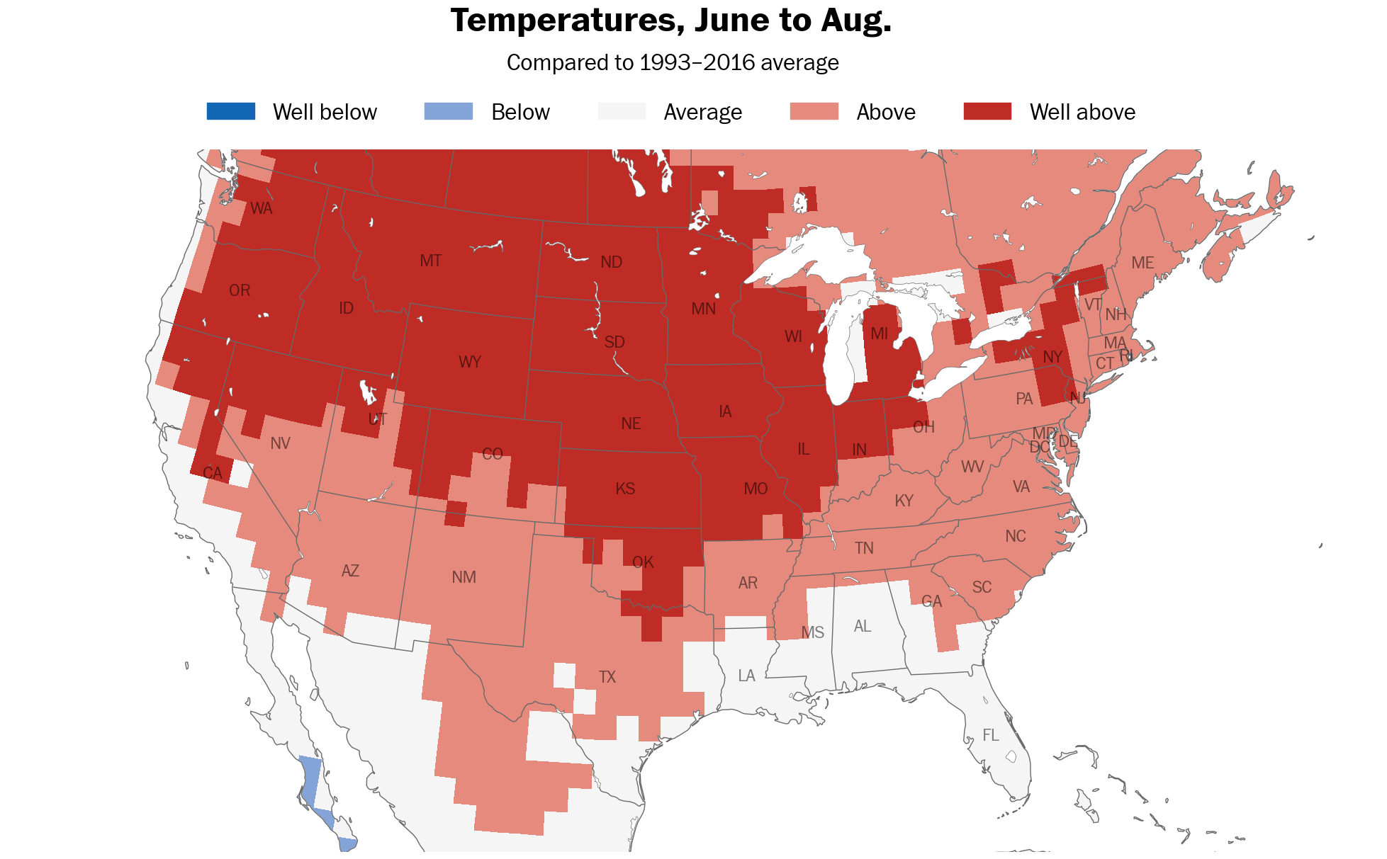
The summer season is unlikely to be cooler than average across most of the country according to the models, especially in western and central states.
But that doesn’t mean that it will be blazing hot and sunny every day in the Hudson Valley.
The nights could end up being more unusually warm than the days, particularly if humidity is extra high.
Precipitation — downpours never far away
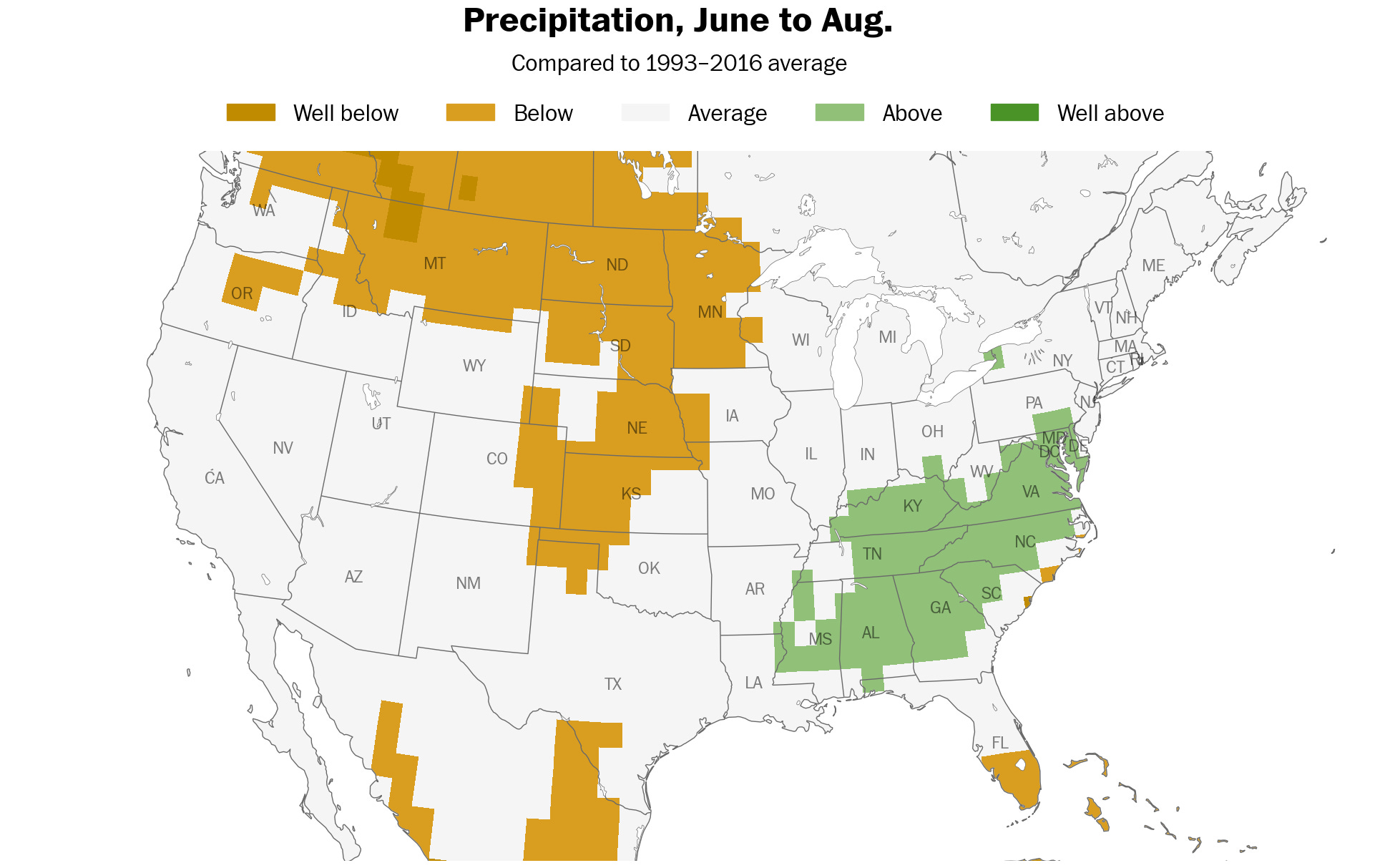
Because of warmer than average ocean temperatures near the Eastern Seaboard, in the Caribbean, and Gulf, there will be more fuel for rain, storms, and hurricanes.
According to the models, July and August look most likely to be wetter than normal in the Hudson Valley.
Strands of green on the above map indicate the the potential for more rainfall than normal along the East Coast.
Humidity — it’s looking unusually muggy
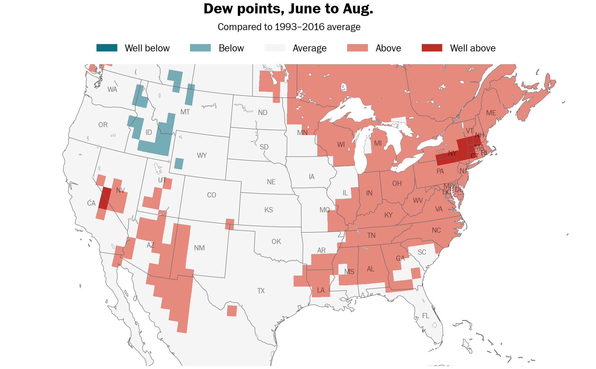
Warm seas and extra moisture near the East Coast likely mean higher humidity. Humidity is trending upward in the Northeast and the upcoming summer will probably be aligned with that long-term trend.
June through October all show signs of being muggier than normal due to unusual ocean heat in the western Atlantic.
Cloud cover — plenty of sunny days
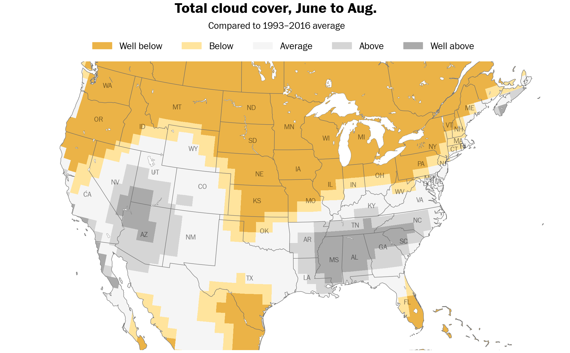
It may seem counterintuitive, but despite the potential for more storms, it still looks like there will be plentiful sunshine this summer.
Below normal cloud cover is predicted across the northern tier of states, including New York — perfect for some trips to the beach.
Last word
Climate is what you expect, weather is what you get. To find out what the region will get, you’ll have to keep following along each week!
In the meantime, enjoy the upcoming warmer weather and thanks for being a premium subscriber.
Hope your summer is filled with good times (and mostly good weather) ✌️

Got me a Daikin whole house air conditioner to keep the humidity inside my home comfortable, between 45-50%. It is extremely energy efficient!