Cool, wet, warm, windy 🍁
Update #416
Hello there and a good Sunday morning to you!
This week will have a little bit of everything, with a cool and wet start, a warm and dry middle, and a windy finish.

After a dry day with increasing clouds today (Sunday), the remnants of Delta will move into the region tonight, bringing beneficial, soaking rainfall from Monday into Tuesday. Around an inch of rain is expected.
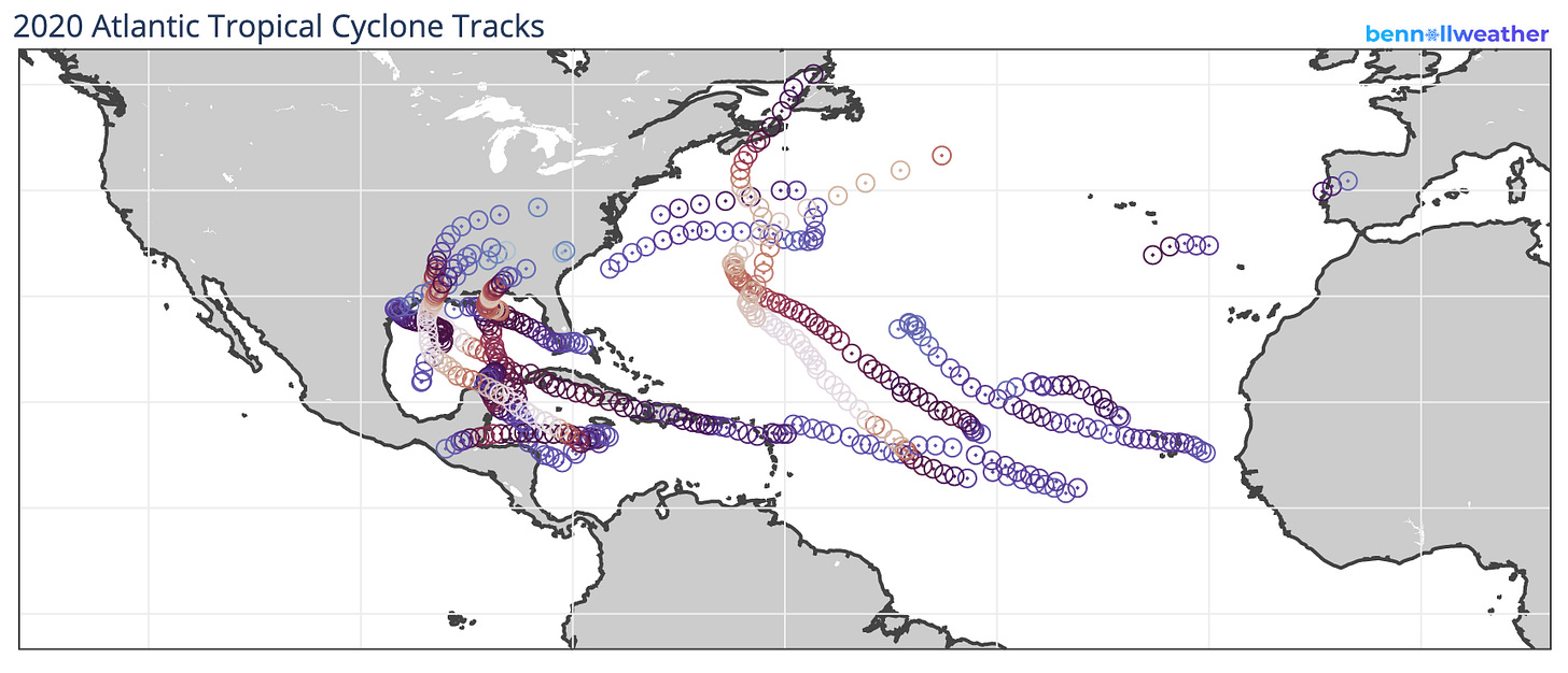
Delta’s impact in Louisiana meant that the U.S. mainland has now had 10 tropical storms or hurricanes make landfall this year, breaking the record of 9 set back in 1916.
This year’s tracking map is frankly dizzying and we may not be done yet. The relative lack of activity between Florida and North Carolina has been made up for by a booming season in the Gulf of Mexico.

Stronger storms are depicted by hotter colors (red/white circles)
Meanwhile, back in the Hudson Valley, Tuesday will start off dreary and drizzly with clearing expected during the afternoon.
Wednesday will be the pick day of the week with a warm afternoon and light winds. Thursday looks to be warmer than Wednesday, although it will be quite windy during the afternoon 🌞 🌬️
The pleasant conditions will come to an end on Friday as a strong cold front approaches from the west. It will come with some rain and the potential for gusty winds — timing to be determined.
Gusty winds will accompany the cooler conditions on Saturday. At this point, high pressure looks to build in for Sunday, yielding tranquil weather.
The topsy-turvy conditions will continue into the week of the 19th, as coastal low pressure could spawn as a result of clashing air masses.
For now, it looks like the coldest conditions relative to normal will hang out farther to the west, over the central states, where some early season snow looks likely over the next 2 weeks! ❄️
📣 Speaking of snow, my Hudson Valley winter outlook will be out next weekend. I really look forward to sharing it with you!

A potent upper atmosphere disturbance (blue) will affect the central states later this week, bringing the potential for some early season snow

Snowfall over the next two weeks — watch how the map fills in across the northern Plains and Upper Midwest with a signal for some flakes across the Great Lakes and even elevated parts of the Northeast!
On the other side of the world
Here are a few photos from my “backyard” here in New Zealand, otherwise known as Auckland’s wild west coast. Numerous nature walks amid sweeping terrain and stunning vistas make it easy to forget that an urban center is just 40 minutes away.
The weather here is comfortably mild with temperatures in the low to mid 60s, typical of mid-spring. The palm trees may give the impression of a much warmer climate 🌴
The location is Piha and the big rock is called “Lion Rock”. The third photo was taken atop the Lion Rock.


Donate
My forecasts have always been free. I do it out of my passion for the weather and find enjoyment in trying to stay one step ahead of Mother Nature. Thanks for coming along with me on the journey!
For years I’ve actually paid out of pocket to keep up my mailing list. I fund my efforts partially through my merch: https://teespring.com/stores/bennollweather
Your donations are much appreciated: https://www.paypal.com/cgi-bin/webscr?cmd=_s-xclick&hosted_button_id=UZBXYEUA89SPC&source=url

