This winter in the Hudson Valley will coincide with the strongest El Niño on record.
Some 4,000 miles away from our region, in the east-central equatorial Pacific, ocean temperatures are around 15°F above average in spots. That represents a huge warming in the ocean, which requires much more energy to heat up than the land.
That’s going to leave a mark, because what happens in that part of the Pacific doesn’t stay in the Pacific — it affects weather patterns worldwide.
Thunderstorm activity transfers the heat from the ocean to the atmosphere, changing the jet streams which guide storms around the planet.
Here’s what this mega anomaly looks like from the perspectives of satellites, buoys, and floats, which measure ocean temperatures.
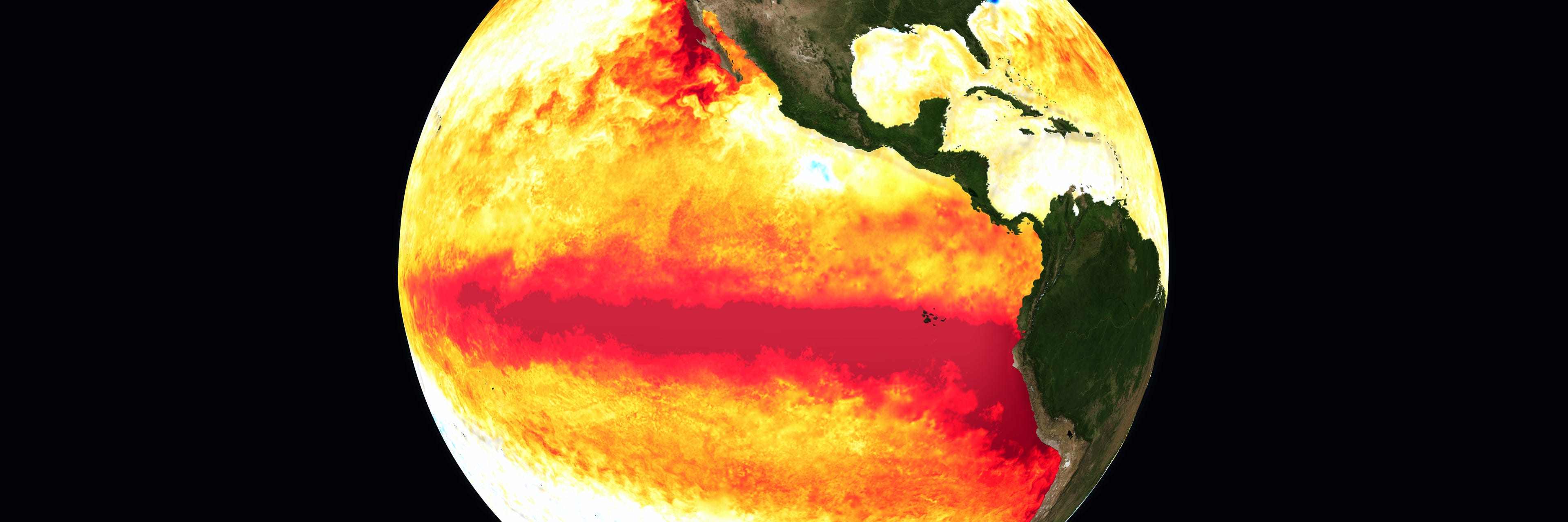
I expect that this remote red stripe in the ocean will leave its fingerprints all over the Hudson Valley’s weather into 2027, affecting chances for rain, snow, and cold temperatures — starting with a transition to stormier weather in November.
Come be an atmospheric detective with me and learn much more! 🕵️♂️
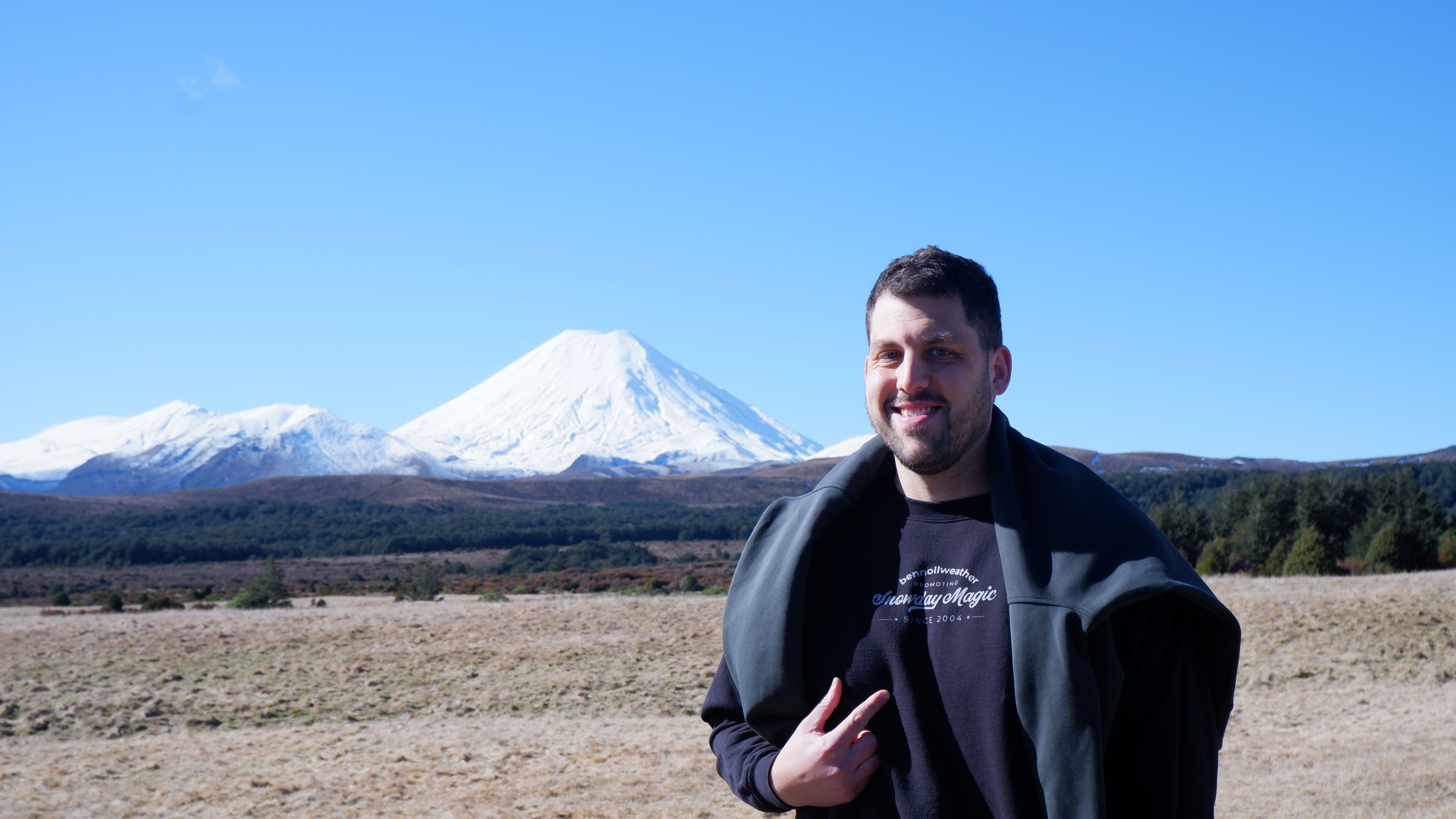
But first, new merch!
This year’s theme is simple but bold:
Not AI Weather. BenNollWeather.
The best snow day forecast doesn’t come from a machine — yet!
Check it out, and grab some here if you want: https://bennollstore.com/collections/not-ai-weather-bennollweather.

El Niño has its hands on the wheel
How exactly do you make a confident forecast when there isn’t a modern historical precedent for the event you are facing?
Hey! If you’re here for the bullet point version, scroll to the bottom of the post. If not, keep reading 🤓
There is undoubtedly an element of mystery around the extreme nature of the impacts that this El Niño may trigger.
However, we can start with what happened the last two times that winter coincided with a powerful El Niño: in 2015-16 and 1997-98.
In December 2015, it reached 70 degrees on Christmas Eve in the Hudson Valley. Then, during January 2016, New York City had its biggest snow storm on record while the Valley was narrowly missed.
In early 1998, it barely snowed at all and it reached 90 degrees by the end of March. It was mild in early January that year, but a few hundred miles to the north, one of the worst ice storms on record unfolded.
And here’s one more: during an intense El Niño in 1983, a 20-30-inch snow storm, named the megalopolitan blizzard, hit parts of the Hudson Valley in February.
History tells us that we should be prepared for weather extremes this winter.
Compared to the last big El Niño over a decade ago, there’s more warmth — and moisture — baked into the climate system, which should make the weather somewhat more radical this coming season.
As a start, I think a repeat of last winter’s “blast from the past” level of cold is very unlikely. Cold air is more likely to be fleeting than persistent. Humidity will probably be elevated compared to winter norms.
All that warmth along the equator will cause more evaporation, loading the atmosphere with more moisture. Some of that moisture will flow toward the United States, where it will be harnessed by storms.
Because of that, storms this winter could have more “boom” potential — if well-timed cold air links up with all that moisture, then boom, a blockbuster snow event could suddenly become possible, especially in the new year.
But what’s more likely is that this winter will be notably rainy and perhaps windy in the Hudson Valley.
That stripe of extremely warm ocean water along the equator in the Pacific fuels towering thunderstorms that transfer heat from the ocean to the atmosphere. That extra heat results in a more powerful jet stream across the western, southern, and eastern United States, creating a coast-to-coast storm train that increases the chances for powerful nor’easters, like the one the region experienced during September.
Climate model data that I analyzed showed that twice as many strong storms as normal could form near the East Coast this winter. Around 18 are predicted, compared to a normal of nine.
States such as California and Florida are also preparing for an exceptionally stormy winter.
History tells us to expect a wet winter
Weather history can provide a glimpse into what the next several months could be like.
The four most powerful El Niño events in the last 70 years occurred in 1972-73, 1982-83, 1997-98, and 2015-16. The most recent El Niño event occurred in 2023-24.
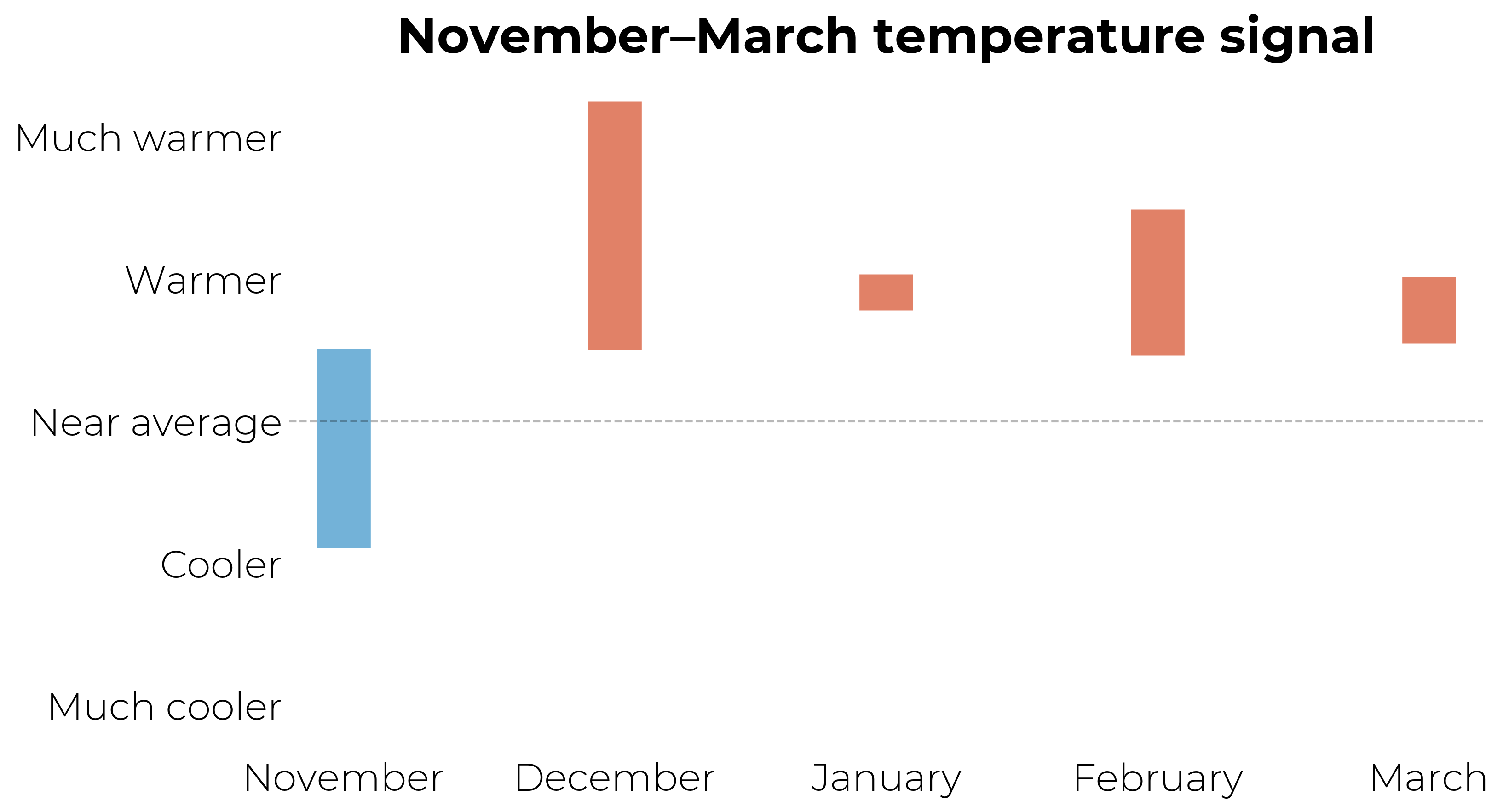
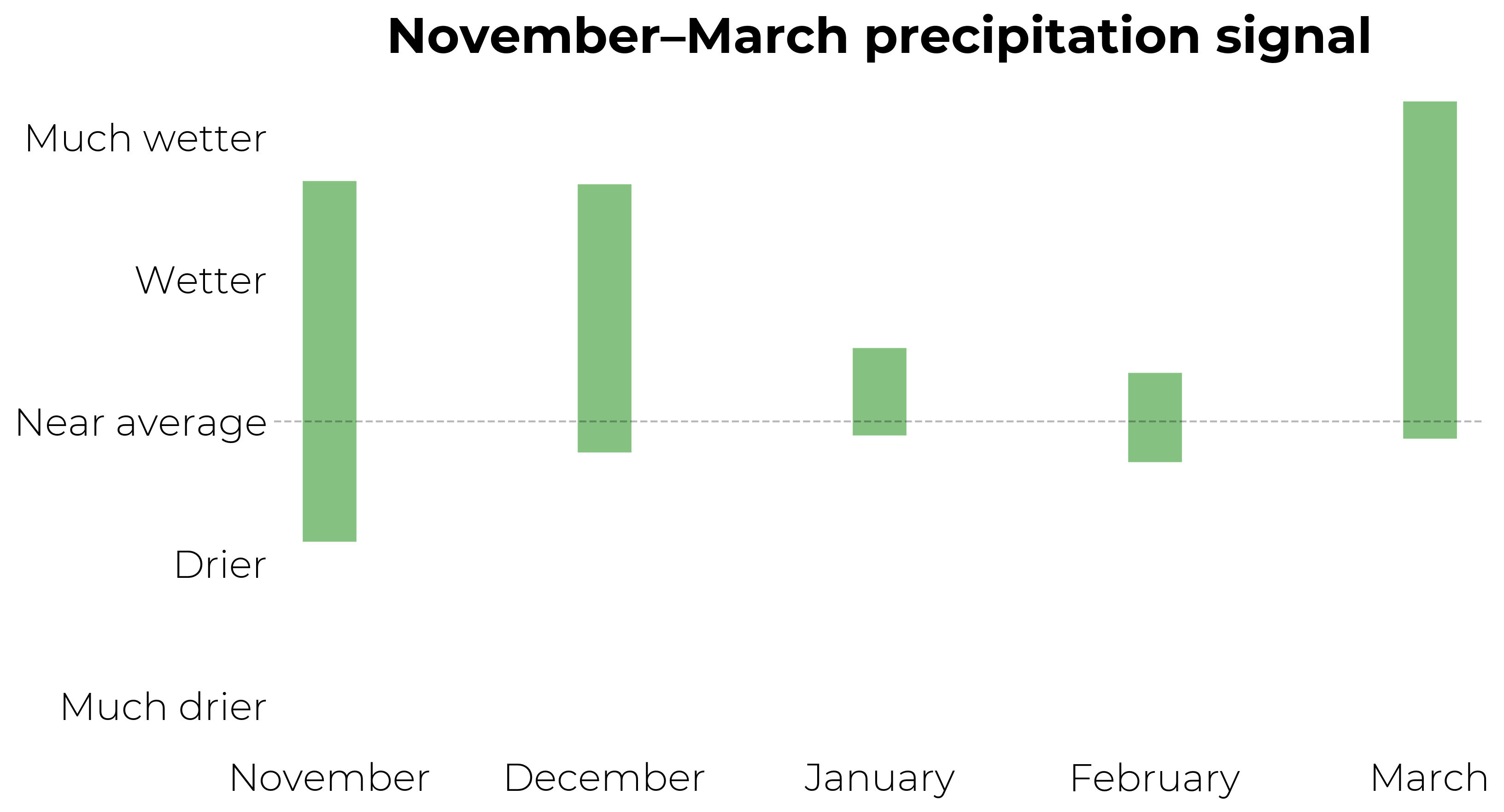
The plots below consider weather conditions during those winters to illustrate a possible direction of travel for the upcoming winter — because history often repeats! The bars indicate the possible range of conditions.
Temperature-wise, it looks quite unlikely to be colder than average. December has the strongest signal for mild air, while January through March all look somewhat above average. The planet is warmer now than it was even a decade ago, and especially compared to the late 1990s or early 1980s. That matters too.
It’s quite possible, if not likely, that elevated levels of humidity will be felt at times this winter, especially during December. Who knows, maybe it will be 75 and humid on Christmas this year 🙃
Based on the historical data, around five days this winter could have sharp humidity spikes.
The chance for a drier than average November to March period in the Hudson Valley is very low. El Niño and warm seas along the East Coast will increase the odds for a wet, stormy winter. Historical data suggests that around 35-40 wet days could be packed into this period, with a few days probably coming with a risk for flooding.
However, if a well-timed blast of Arctic air collides with a blob of moisture from the tropics, explosive things could happen in the snow department 💣 ❄️
That’s one of the most intriguing aspects of this upcoming winter.
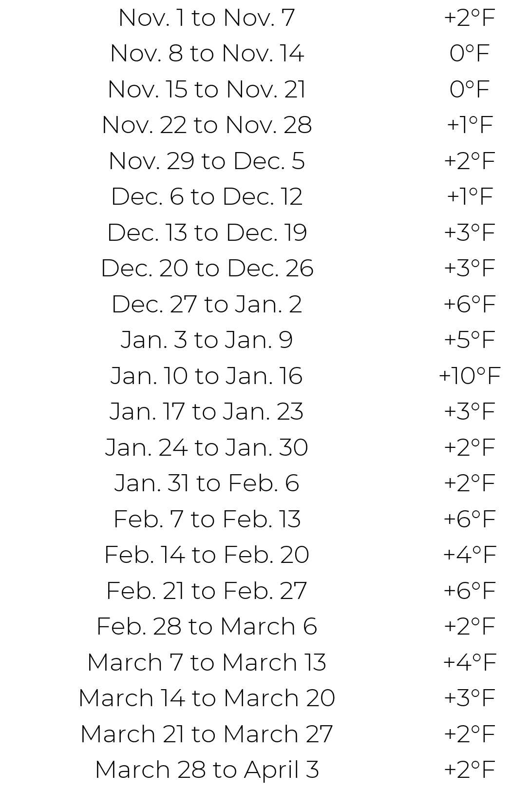
Winter is the Hudson Valley’s fastest warming season. But which weeks during the season have warmed the most? The chart below compares average weekly temperatures in the last decade to that of the period from 1961-1990.
Based on these trends continuing or accelerating, I think someone growing up in the Hudson Valley a century from now will experience far fewer snow days than the generations before them, as the region’s climate becomes more like that of the Mid-Atlantic and, in the distant future, the Southeast.
Less snow than normal to start winter
Computer model forecasts, which account for El Niño and all the factors that will influence the weather in the months ahead, generally agree with the historical data.
They show below average snowfall in the Hudson Valley during November and December, but that signal fades in the new year. The video below shows how snow patterns are predicted to change throughout the season.
Here’s what I wrote about this snowfall outlook on social media:
Will it be a snowy winter? Here's what the latest data shows! ☃️
A record El Niño will bring ample moisture to the U.S. this winter — outside of the Pacific Northwest — but that moisture won't always be met with cold air.
That's especially true in December, when the Northeast and Great Lakes are confidently predicted to have less snow than average.
On these maps, areas with a dashed outline mean that five out of six models agree on the outcome shown, which conveys confidence. These maps are best interpreted as a broad estimate of winter snowfall patterns, rather than a precise forecast for any one location.
From December into January, a signal grows for more snow than normal across the West and Plains, stretching from California's Sierra Nevada to Denver and maybe even Dallas.
There's also a bubble of above average snow that develops over the southern and central Appalachians, including Atlanta, Columbia, South Carolina as well as Charlotte and Raleigh in North Carolina.
A similar snow signal continues into February.
Although there's a relatively strong signal for less snow than normal across New England all winter, the rest of the Northeast is a more interesting case.
There will likely be many big coastal storms which could bring rain to the coast but the potential for significant snow inland.
These "high ceiling" storms appear to be a wildcard in the winter ahead. It will all depend on whether there's enough cold air in place to cash in on all that moisture as snow.
The bottom line
Here’s the bullet point version of this winter outlook.
A winter as cold as the last one is very unlikely
December has the strongest signal to be warmer than average
A stormier, wetter, more humid and windier than normal winter is likely, with some flooding events possible
There’s elevated potential for a big storm that delivers a lot of snow, especially in the new year
Because of expected milder conditions, snow and ice will probably occur less frequently and won’t stick around for long
Next month, premium subscribers will gain access to a big forecast product upgrade. I think it will change the game when it comes to snow day predictions, and it will soon be in your hands.
We’ll all be more prepared this winter, no matter what Mother Nature throws our way!
Thanks as always for your support.