
Snow update
Update #425a

Good morning all. It’s me, Ben Noll, again! I’ll have updates right through the big Wednesday-Thursday storm with additional coverage on Facebook and Twitter.
First, today’s snow: a swath of wet snow will track across the Hudson Valley from about 8:00 am to 4:00 pm. Snow will fall moderately at times from 9:00 am to 1:00 pm.
On my website, I’ve got a radar that has Hudson Valley schools as location markers. I’d suggest bookmarking the page — it will make tracking precipitation a breeze.

Although above freezing road temperatures will make sticking a challenge at first, secondary roads, sidewalks, and non-paved surfaces could become covered later in the morning or early in the afternoon. Air temperatures will hover near or just above freezing.
In total, an inch or two is possible with the highest amounts along and south of I-84 but north of I-287.
Wednesday-Thursday
Confidence is increasing on a high impact winter storm from later Wednesday into Thursday morning.
What? Snow, becoming heavy, and gusty winds. The heaviest snow is expected on Wednesday night.
When? Beginning from south to north during the mid-to-late afternoon on Wednesday, potentially affecting the PM commute. The start time will be earlier to the south (e.g. south of I-84) than it will be to the north. Ending on Thursday morning.
How much? Over a 90% chance for more than 6 inches. A 60% chance for more than 12 inches. A 30% chance for more than 18 inches.
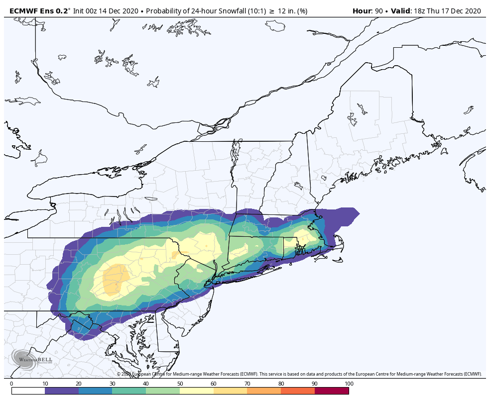
Impacts? Road conditions will deteriorate when the snow starts later on Wednesday afternoon and become extremely treacherous Wednesday night until Thursday morning. A significant cleanup will be needed on Thursday.
Early dismissals remain more likely than not for Wednesday but it will ultimately depend on the start time which will become clearer over the next day or so. The storm may battle dry air at the onset, which means that areas north of I-84 may take more time to get into the snow.
Closures continue to be favored for Thursday as the snow ends and cleanup begins.


With temperatures in the 20s on Wednesday night during the apex of the event, the snow consistency is likely to be quite powdery, which will allow it to pile up quicker. Snow blowers should handle it well!
The National Weather Service will likely post a Winter Storm Watch in the next 24 hours and I’ll report on it when it becomes available.
I’ll have another update tomorrow. Have a great day!