
Weather: here's how 2020 will end
Update #427

And just like that, we’re here. The end of 2020. In my final Hudson Valley weather report of 2020, I look back at some of the year’s key climate stats and look ahead to the start of 2021.
Looking back
Consistent with our trend of a warming climate, 2020 will go down as the 3rd warmest year on record in the Hudson Valley according to the long-term climate site in Poughkeepsie. The average temperature (average of the daytime high and nighttime low temperatures) was 53.1 degrees. This was 3.5 degrees above the 30-year average, as calculated between 1981-2010.
Just this week, the Hudson Valley experienced its warmest Christmas on record! The temperature reached 65 degrees around 4:00 am on Christmas morning. In true 2020 form, the temperature gradually dropped throughout the day, giving way to snow before the day was through.
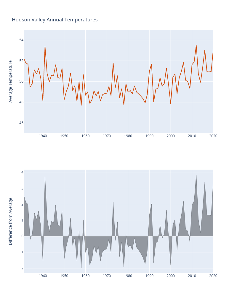
🌡️ Hottest temperature: 97˚F, July 27th
🥶 Coldest temperature: -3˚F, December 19th
💧 Wettest month: May (3.47 inches)
❄️ Snowiest month: December (13 inches)
☀️ Driest month: June (1.12 inches)
💨 Windiest month: April (7.1 mph)
Do you have a weather photo that you feel encapsulates 2020 in an image? Feel free to email it to me, I’d love to feature it in a social media post!
Looking ahead
Mother Nature has a few tricks up her sleeve before the year comes to a close.
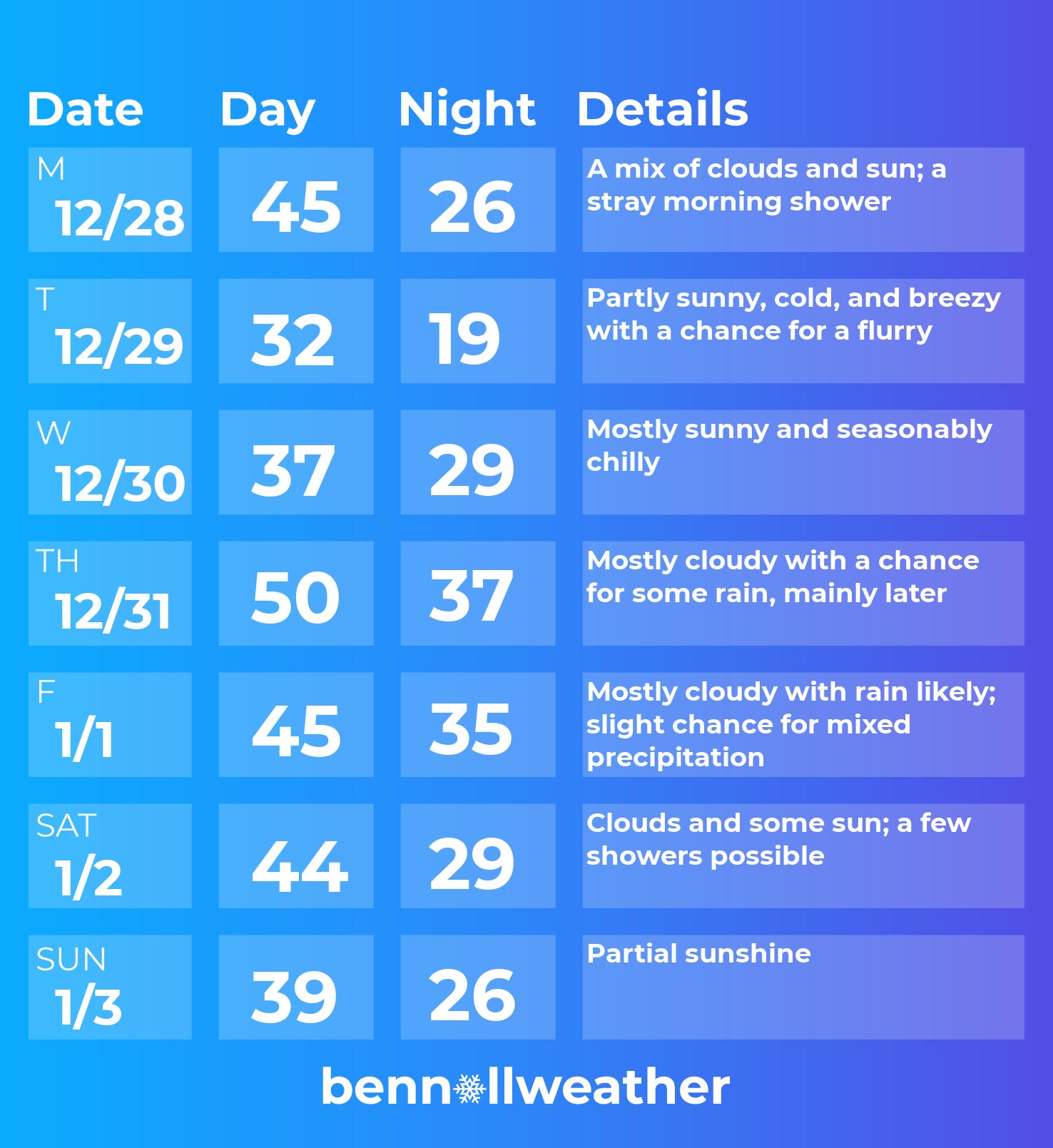
Monday could have a passing shower, but otherwise it looks relatively mild.
Tuesday looks quite chilly and windy following the passage of a Canadian cold front — flurries and snow showers are also possible.
Wednesday will have a particularly cold morning, but dry weather is expected to prevail.
Things start to get a bit more interesting on New Year’s Eve as a front approaches from the west. A mild, southwesterly air flow ahead of the front means that precipitation will most likely be in the form of rain.
Thursday night, the cold front could make its way through the region, causing a drop in temperatures. The timing and location of this front is important, because…
Another low pressure system is expected to pass to the west of the region on Friday, dragging in more moisture. If the aforementioned cold front makes it through the region, there’s a chance for mixed precipitation. If not, additional plain rain would be likely.
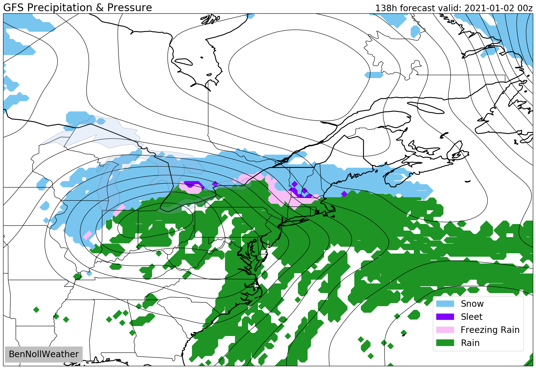
At this point, it looks like most of the disturbed weather will pass to the north and east by next weekend, but some lingering showers can’t be ruled out.
Looking ahead to the week of January 4th, relatively mild temperatures appear likely in the east as wintry weather affects the western states.
On the other side of the world


Thanks for your readership and support this year. Your interest is the fuel that keeps my forecasting engine going! I’ve got 52 weeks’ worth of updates coming for you in 2021, catch you next year!
Happy New Year and thank you for 2020 coverage!! Looking forward to 2021~~~