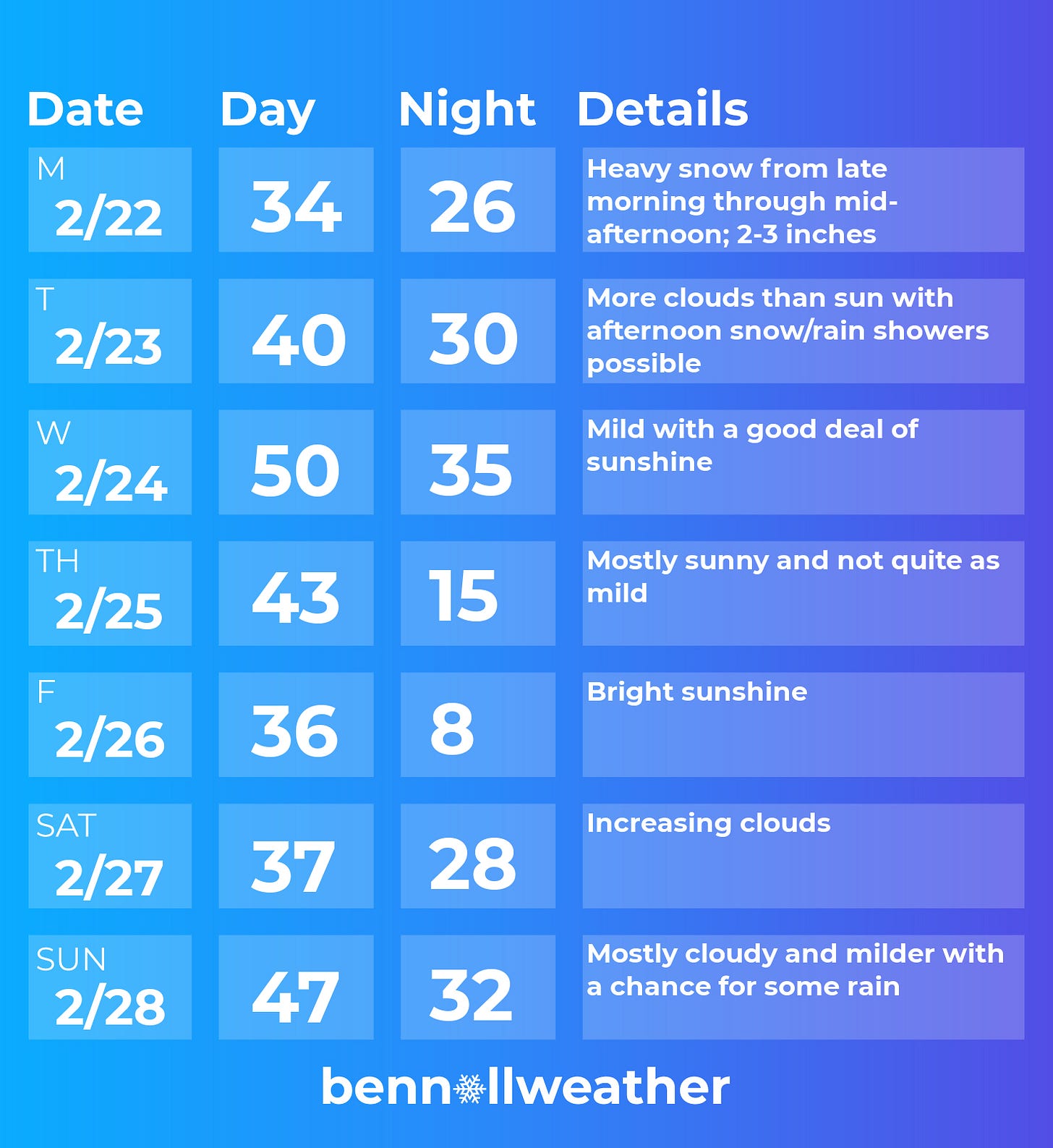
Welcome to the latest update on Mother Nature’s antics during February 2021!
The next chapter will be written in the middle of the day on Monday, as snow falls fast and furious for a few hours.
The event will see the region reach 50 inches of snow season-to-date, about 10 inches above the long-term seasonal average.
Without further ado, here’s what you need to know:
What? Heavy snow.
When? Beginning from 10:00 am-noon Monday from west to east. Ending between 4:00-6:00 pm.
How much? 2-3 inches for most, isolated 4 inch amounts.
Impacts? Unlike the last storm which featured light snow for about 40 hours, this one will come with almost as much snow in 1/10th of the amount of time. Road conditions are expected to deteriorate after snow starts late Monday morning with the worst conditions expected early Monday afternoon. It won’t be a good time to be on the roads. The impact will be short but sharp — don’t be caught off guard, it will get slick quick! If you have travel plans between about 11:00 am and 3:00 pm Monday, my advice would be to hold off if you can. By the start of the evening commute (4:00-5:00 pm), things should be winding down from west to east. Near or just above freezing temperatures should help crews get a handle on things upon the snow’s completion.
The awkward timing of the snow means that schools, many of which are coming back into session this week, may have to go remote (if they have the option) or close. The problem with early dismissals is that students may be dismissed into the snow, not to mention administrators, teachers, and other staff traveling home in the early afternoon as road conditions worsen. The intensity of the snow is the concern — if we were dealing with a lighter variety of snow, early dismissals might be OK, but that’s not what is expected here.
A quick “behind the curtain” comment on the forecast involves something known as significant lift or rising air through the dendritic growth zone (DGZ). A meteorologist looks at this parameter to assess the type of snow (snowflake structure and intensity) that may occur. When there is lift through the DGZ, as is predicted on Monday, it suggests that snow can fall heavily and accumulate quickly.
The rest of the week looks much less eventful (yay!) 🥳
It will be milder than recent weeks, with 40s and even a 50 making an appearance on the seven day forecast.
Some snow or rain showers could cross the region Tuesday afternoon, although these are not expected to cause issues.
Wednesday looks like the pick day of the week with warm temperatures for the time of year and sunshine.
Thursday won’t be as warm with some Canadian air filtering southward. The relative chill will be felt from Thursday night through Saturday morning.
A storm system looks like it will gather in the country’s midsection next weekend, possibly affecting our weather late in the weekend or early in the first week of March.
Sustained cold air will likely continue to fade as we head into March. While this won’t eliminate the risk for winter storms, it will make them harder to come by.
For additional updates regarding Monday’s snow, follow along on Twitter. I will probably send another email update early on Monday morning.
Fire in the sky
This was the view from “the future” — my balcony on Sunday evening. It was the most vibrant sunset of summer in Auckland 🌄
Have a great week!
With winter soon wrapping up, show your appreciation by grabbing some merch or giving a donation. Try promo code “stormy” for 20% off 😊


