
A month's worth of rain as Ida infiltrates Hudson Valley
Update #462a

Hello there! I didn’t think I’d have to post school closing percentages on the first day of school, but here we are! 🙃

After leaving a trail of destruction in Louisiana, Ida’s remnants have joined forces with a front and are taking aim on the Northeast.
For the Hudson Valley, what does this mean? Well, as the saying goes, a picture is worth a thousand words:

That’s the predicted radar from this morning through Thursday morning, showing shades of orange and red racing across the Hudson Valley.
The animation is a little fast, so I’ll break it down into bite-sized pieces:
This morning and afternoon (through 7:00 pm): light rain becomes moderate to locally heavy by afternoon — widespread issues unlikely to develop yet.
This evening and overnight (7:00 pm-4:00 am Thursday): this is when conditions will go downhill. An area of very intense rain will track into the region from the west. Hourly rainfall rates between about 9:00 pm and 2:00 am could reach as high as 0.50 to 1.00 inch. To put that in perspective, the region averages 4 inches of rain in the entire month of September — we could see that much in 4 to 6 hours! While rain will be the main story, wind gust strength has trended progressively stronger: gusts of 30-45 mph will be possible during the heavy rain. The combination of very wet grounds and moderate wind gusts may be enough to cause sporadic power outages. The thunderstorm risk is highest from about New York City southward, although one can’t be entirely ruled out for the lower Hudson Valley.
Thursday morning: by about 4:00 am Thursday, the worst of the weather will have likely pushed off to the east. However, when it comes to extreme rainfall, the impact is often worse after the rain as stream and river levels continue to rise for a while. This is one reason why the Flood Watch issued by the National Weather Service continues until 2:00 pm Thursday.
Possible impacts include: flooding of roads, basements, flash flooding of creeks and streams, and washed out roads. Areas that are prone to flooding will be at highest risk. Remember to never drive through floodwaters — it’s just not worth it! If you find yourself in a flash flood, get to higher ground immediately. Here are some tips on what to do during a flood.
In total, 3-6 inches of rain is expected from the remnants of Ida. Localized higher amounts will be possible, particularly over higher terrain. That is a month’s worth of rain or more.

You can track the rain on my local Hudson Valley radar, which has many area schools pinned: https://www.bennollweather.com/weather
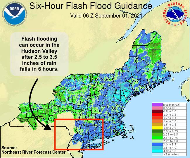
The image below shows the amount of rain needed over a 6-hour period to cause flash flooding. Across the Hudson Valley, 2.5 to 3.5 inches is what it will take.
River levels, such as the Wallkill, are predicted to rise rapidly but due to the relatively short duration of the rain event look unlikely to reach flood stage. Caution is required here, particularly if rainfall totals exceed expectations.

The intensity of Ida’s rain is what will separate it from Henri. Frankly, it may be difficult to fall asleep on Wednesday night because of it!
Administrators should be prepared to assess the situation early on Thursday morning to ensure safe travel for staff and students as conditions may differ significantly over short distances. This will depend on exactly where the heaviest rain falls and any flooding-related issues occur.
Best wishes on your first few days. Hopefully the next percentages I issue are for a snow storm, not a tropical storm 😉
I provide all of my forecasts free of charge. If you find them useful, please kindly consider a donation by clicking the button below 😊