Mother Nature's March madness 🎢
Update #488
We’ve reached the time of year when the temperature can range from 20 to 70 in a week and the threat for snow transitions to thunderstorms 🥴
Flowers may begin to pop out of the ground at the promise of warmer temperatures, only to be shocked by a Canadian cold front a few days later.
As for snow? We’re not out of the woods quite yet. However, with longer days and warmer temperatures, accumulating snow gets harder to come by. A mobile weather pattern over the next 2-3 weeks will give us a chance for wintry precipitation, but a lot has to go “right” for it to be disruptive!
This week…
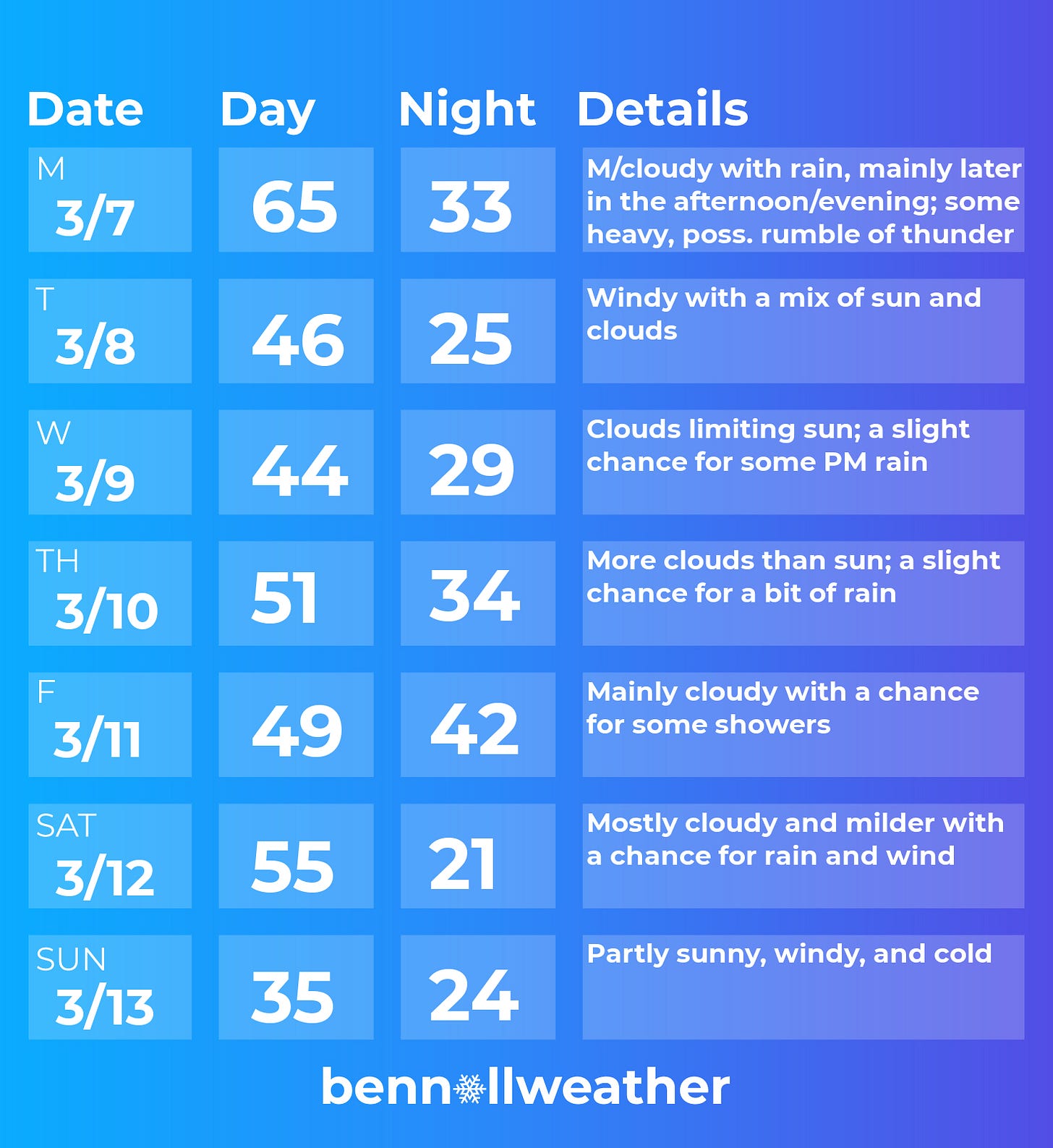
After a period of late morning and early afternoon rain today (Sunday), it will turn quite warm with temperatures rising well into the 60s ~ a true taste of spring!
Monday will be another topsy-turvy weather day in the Hudson Valley as a front approaches. During the afternoon, temperatures are expected to range from the 50s to lower 70s across the region from north to south! 🌡️
There may be a bit of morning rain, but the bulk of it will likely arrive later in the afternoon or evening. A rumble of thunder can’t be ruled out and the rain will likely be heavy for a time ⛈️ — something to keep in mind if you’ll be traveling late in the day on Monday…
A sharply colder air mass will blow in on Monday night, leading to a cooler and windy day on Tuesday.
On Wednesday and Thursday, clouds will limit sunshine as a few weak disturbances pass off the Mid-Atlantic coast. At this time, each day has a chance for a bit of rain in the Hudson Valley, but could also turn out dry.
On Friday, an Arctic air mass will plunge into the central U.S., potentially causing a corridor of disruptive wintry precipitation. The Hudson Valley will probably be on the warm side of the system, with a chance for some rain on both Friday and Saturday. It could turn windy on Saturday as a strong cold front approaches the region 🌬️
By Sunday, a much colder air mass will have likely surged across the East Coast 🥶
If you have plans next weekend, the weather may not be particularly cooperative, so keep an eye on the forecast! With an active pattern, forecast details (such as on your weather app) are likely to be more changeable than normal.
Looking ahead to the week of the 14th, more spring swings are likely. It will probably start cold but turn milder…
This week in New Zealand: a tree..... growing out of a lake!? 🤭
It’s some Harry Potter-esque wizardry.
Called “That Wanaka Tree” or the “Wanaka Willow”, it’s is arguably New Zealand's most famous and photographed tree. It's grown out of Lake Wanaka, in the South Island, along an old fence line for the last 83 years!
Does the Hudson have one? 😅
👋 Have a marvelous week — hope Mother Nature can make up her mind soon!


