Strong storms Monday ⛈️
Update #498
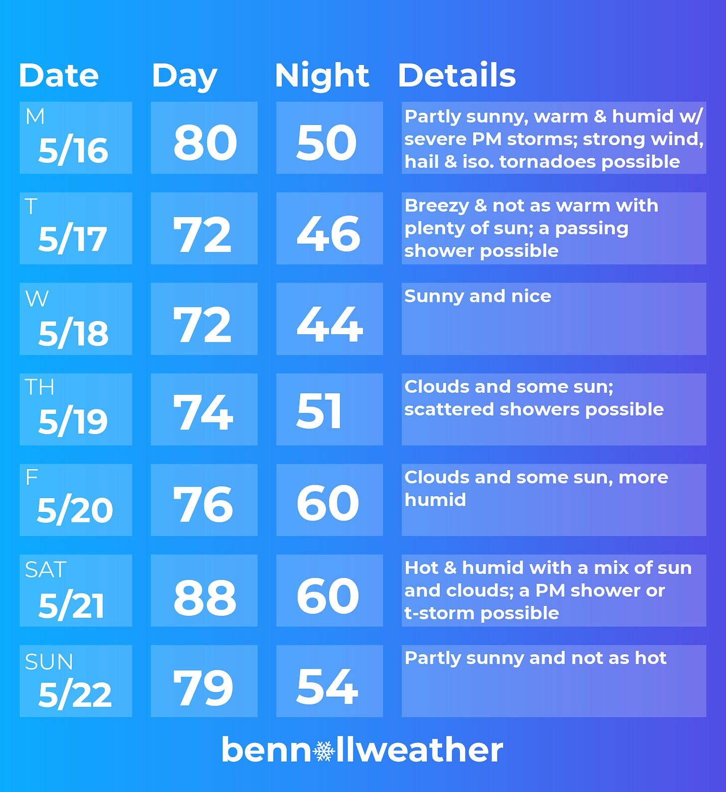
👋 Hi there! The Storm Prediction Center has placed the Hudson Valley in an “enhanced risk” category for thunderstorms on Monday afternoon, citing a risk for strong winds, hail, and even an isolated tornado.
It looks to be our first significant severe weather threat of the season, with the mid-to-late afternoon hours having the highest chance for activity.
After snow day predictions, severe weather updates are my most popular, so I will be providing them as needed on Twitter. Stay weather-aware out there!
Fortunately, the stormy weather won’t last — a cold front will swing through the region on Monday night, blowing the heat and humidity away.
Tuesday will be be a much more comfortable day with a breeze picking up.
Wednesday will be the pick weather day of the week 🌞
Daytime temperatures will continue to run in the 70s on Thursday and Friday with just a chance for some passing showers.
The humidity will start to become more noticeable on Friday before peaking on Saturday ahead of a cold front. Right now, Saturday looks like the hottest day of the year so far with a weather setup conducive to a run at 90 degrees 🌡️
Following a cold front late Saturday, temperatures on Sunday look to turn modestly cooler.
Further down the line, there’s a sign that more heat could build during the second half of the week of the 23rd.
Summer outlook
The polar opposite of my winter outlooks, which are usually the length of a novella, in this tweet I deliver a summer outlook in 280 characters.
🥜 In a nutshell, there’s a sign that it will be similar to recent summers — featuring warmer than average temperatures and high levels of humidity, lasting into fall. That means your AC and window fans will be getting a workout!
It could start off a little drier than normal in June before trending wetter in July-August, possibly turning drier again in fall. The wet weather could again be influenced by tropical storms, as we have experienced in each of the last two summers.
Are you ready for summer? 🔥 Grab this white hot new merch to increase your albedo (reflect sunlight) and stay cool 🧊
Beach trip 🏖️
Has the warmer weather got you thinking of a beach trip? While ocean temperatures have yet to heat up along the Jersey Shore, we’re still experiencing a marine heatwave in New Zealand. Even though May is the month before winter in the Southern Hemisphere, sea temperatures are just shy of 70 degrees in northern New Zealand - perfect for one last dip before the cold season arrives.
I shared some drone photos last week - this week, shots from the ground 📸
🤙 Ride a wave of good vibes this week!


