Cool winds of change 🍂
Update #518
Hi there! The remnants of Hurricane Ian continue to dissolve south of the region today. While the country says good riddance to Ian, it will not soon be forgotten.
The Northeast has been fortunate with no direct hurricane impacts this season, but it’s only a matter of time until the next big one…
While the tropics are now quieter, they may perk back up at least one more time before shutting down until next year.
In Ian’s wake, cooler air is settling into the Hudson Valley, with a sign that October 2022 could buck the trend of recent warm Octobers — especially with what’s coming next weekend 🌬️
The last 3 Octobers and 9 out of the last 12 have been warmer than average. In essence, recent Octobers in the Hudson Valley have been an extension of summer. Last October was about 5˚F warmer than average!
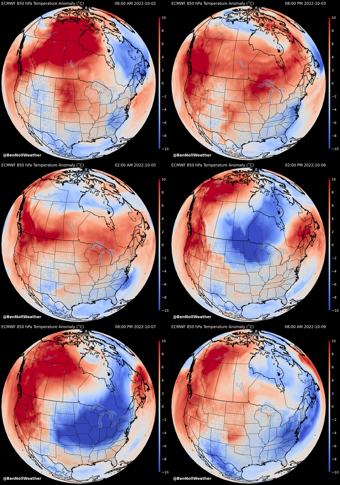
5 degrees warmer than average?! Pffft, not in 2022! An air mass from the Arctic Circle north of Alaska (🔵) has booked a one way ticket to the Northeast U.S. — it will arrive on Friday night.
So locate your favorite hoodie and dust off the warm blankets. Fall is well and truly here!
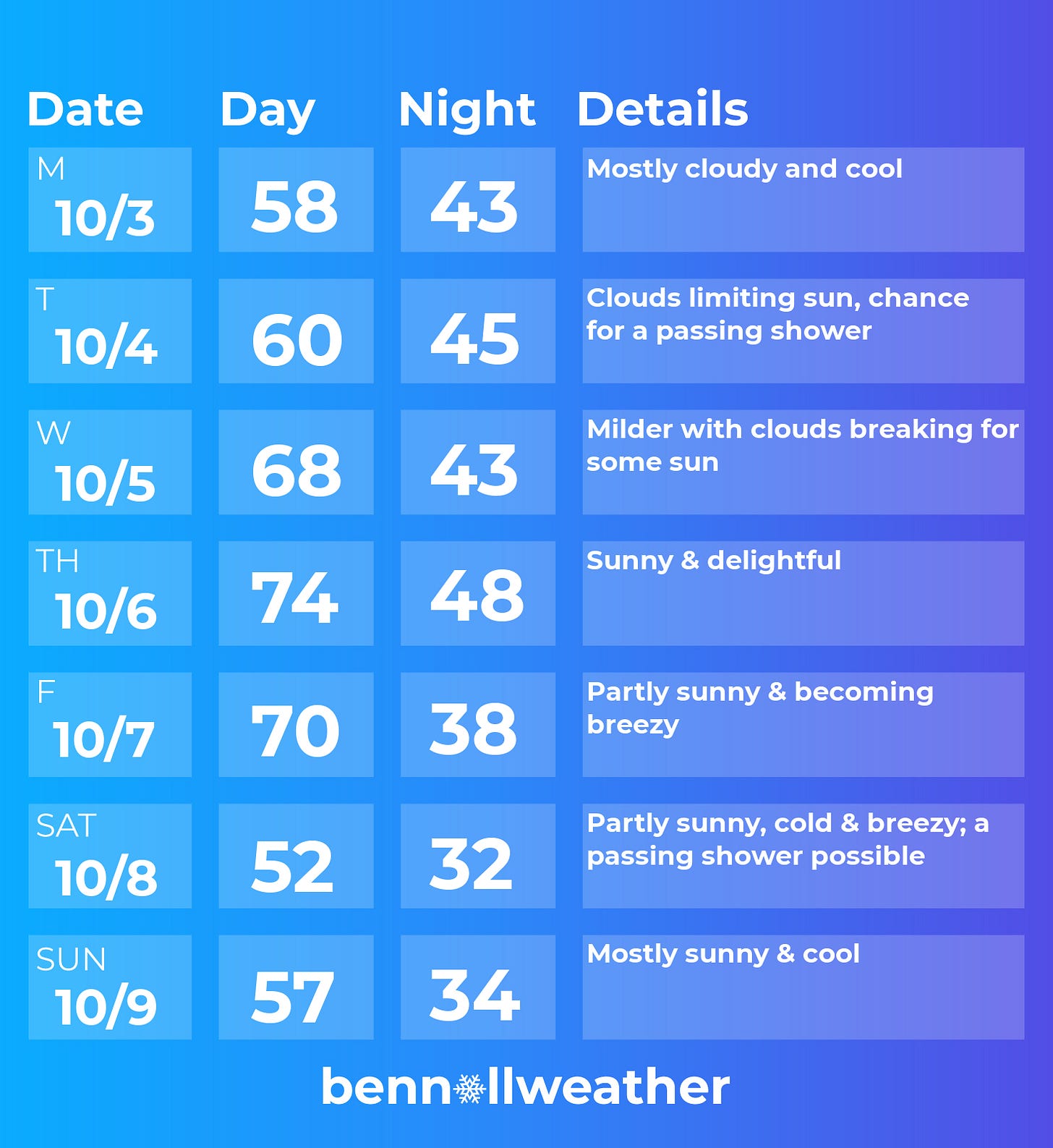
With Ian’s remnants swirling near the Mid-Atlantic coast today (Sunday) through Tuesday, our skies will remain mostly cloudy. I couldn’t rule out a passing shower today or on Tuesday, but it will be dry most of the time. [Update, 5:20 am, October 4th: Tuesday’s forecast has trended wetter with periods of rain likely through the day].
On Wednesday, the mass of atmospheric trash will finally pull away, with clearing skies likely by later in the day.
🥇 Thursday is the clear pick weather day of the week with abundant sunshine and warm temperatures.
On Friday, the Arctic front will approach the region (can’t believe I’m writing that in the first week of October). It will turn noticeably breezier but the front won’t come with much in the way of moisture.
It will pass through on Friday evening with a whole new air mass in place by Saturday morning. Saturday looks to be the coolest day since early May as a stiff northwesterly wind blows.
The first frost of the season is then possible on Sunday morning! 🥶
The weather looks to turn gradually milder from Sunday into the week of the 10th, however, another cool snap looks possible around the 14th.
The silver lining is that the cooler weather will come with drier than normal conditions and a good deal of sunshine ☀️ ~ hopefully some lovely fall foliage viewing weather in a few weeks time! 🍂
There are even some hints that the high elevations of the Northeast could experience their first snow in the next 2 weeks. For more on when the Hudson Valley historically sees its first snow, check out my post below.
Weather overlap
October is the month of the year when the Hudson Valley and my current place of residence, Auckland, New Zealand, experiences similar weather.
🚁 Here are a few drone shots I snapped last weekend amid 70 degrees and sunshine.
Next month, I’ll be headed to the Philippines! My weather reporting for the Hudson Valley knows no geographical bounds.
Embrace the change this week ✌️


