☃️ A wintry week ahead!
Update #527
And snow it begins! ❄️
The Sunday morning radar shows that the Hudson Valley’s first decent, accumulating snowfall event is forming a few hundred miles off to the west over PA.
While a few earlier flakes are possible, accumulating snow will begin between 10:00 am - 1:00 pm, spreading from west to east.
While it won’t be the biggest storm, our pre-4:30 pm sunset coupled with a period of moderate, wet snow from late afternoon through the evening will lead to some slippery road and sidewalk conditions overnight into Monday morning.
⚠️ Accordingly, the National Weather Service issued a Winter Weather Advisory from late this morning through 7:00 am Monday. As of early Sunday, it was expanded to include Rockland, Putnam, and Westchester County — and now includes the whole region.
📏 After an accumulation of 2-4 inches — and even some locally higher amounts to 5 inches over the hills and Catskills — snow will ease to flurries between 3:00-6:00 am Monday.
(☝️ consider upgrading your subscription to premium to be in the know about long-range snow threats! ❄️)
Temperatures will dip into the upper 20s tonight, with untreated surfaces expected to be snow-covered and slippery when you walk out the door on Monday morning. Because of this, school delays are likely.
Around 1:00 pm today, I’ll be posting school-by-school delay percentages on Twitter.
We may even see some school delays announced this evening to, you know, make things easier for everyone in the morning 😉
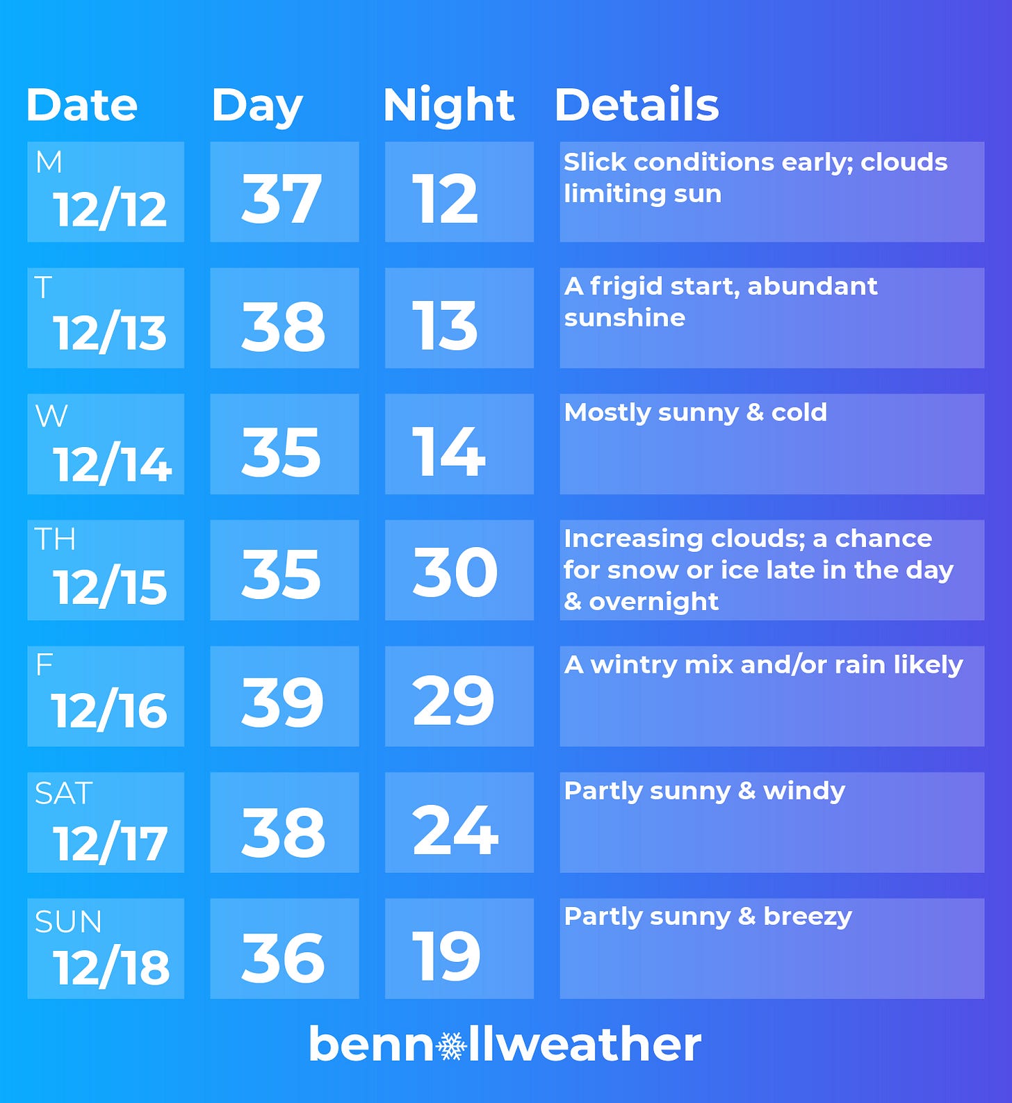
The rest of Monday through most of Thursday looks pretty chill (literally), so shall we just skip ahead to the next event?
Thursday night - Friday 👀
The next storm looks a bit… messy. The details are not yet set in stone, so you’ll definitely be hearing from me again.
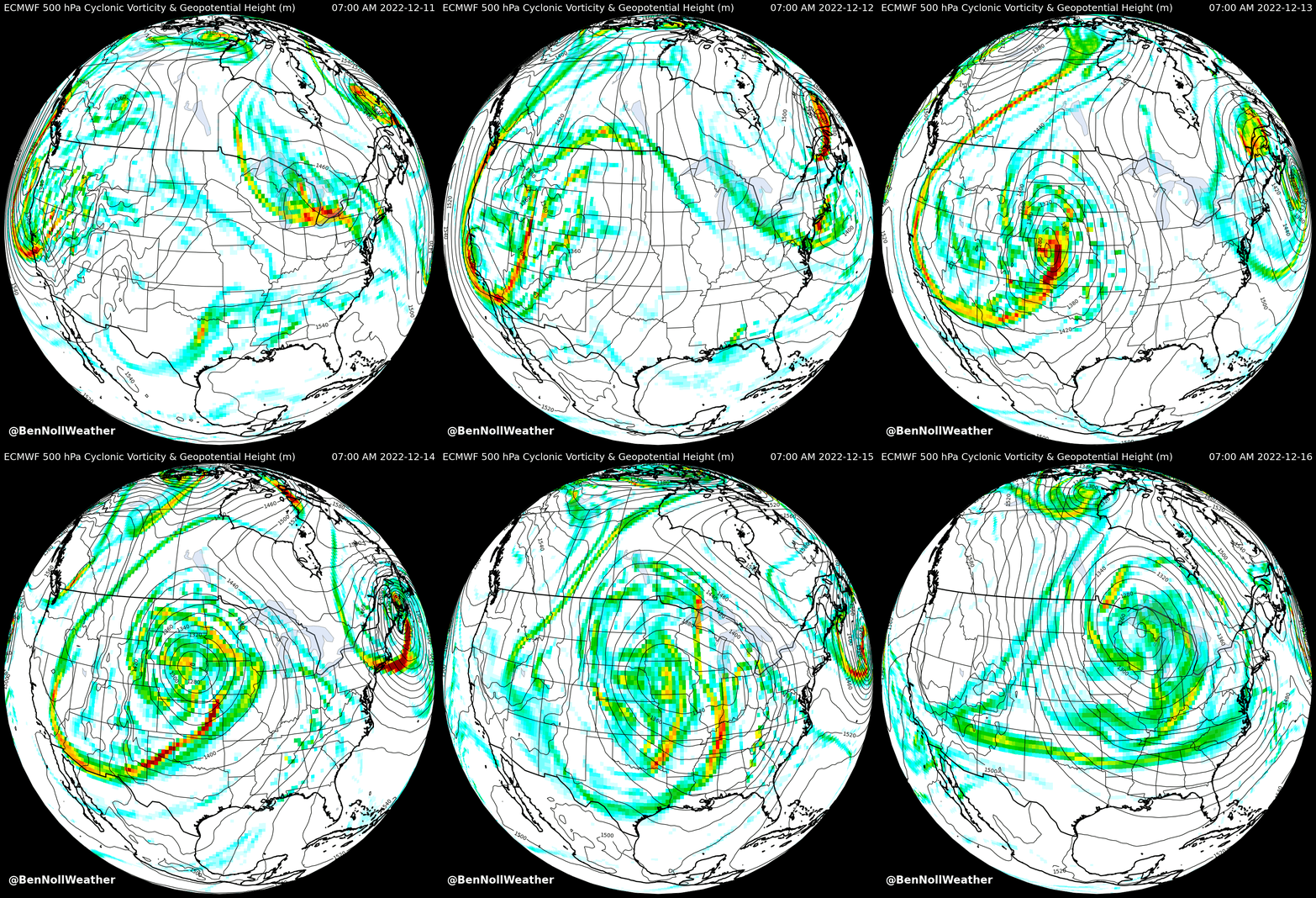
A big bowling ball of low pressure in the upper atmosphere will roll across the U.S. this week. It will likely spur the development of a coastal low (nor’easter) from Thursday night through Friday.
Remember my post from this time last week when I was talking about a monstrous zone of high pressure over northern Canada and Greenland? That feature has a lot to do with the weather the Hudson Valley experience.
It will act as a conveyor of cold, shipping air from north-to-south. Traveling along this conveyor is an air mass from way up in Labrador, Canada — a cold place!
Once the air mass reaches the Northeast on Wednesday, the Hudson River Valley will act as a funnel, channeling the chill southward.
Cold conveyor meet bowling ball 🤝 💥
Things may start to get “interesting” on Thursday afternoon or evening and remain that way through Friday.
❓ There is a question as to how long the cold air sticks around — the storm’s track will dictate how quickly the cold is eroded. An easterly track would allow cold air to linger while a westerly track would dredge up warmer air.
At the moment, a medley of precipitation is favored: starting as snow before changing to ice and then maybe rain.
At this point, I’d say there’s a medium chance that school will be impacted on Friday, but maybe Thursday afternoon/evening too. One way or the other, I’ll keep you informed.
🥶 Next weekend is currently looking cold and windy with lake effect snow possible farther upstate — keep this in mind if you or someone you know is due to travel home from college!
Who left the freezer door open? The animation below shows that there’s a strong chance that the lead up to Christmas will be colder than average (🔵) this year!
Although the week of December 19th looks cold but dry to start, there will likely be additional storm threats before Christmas ~ stay tuned! 🌨️ 🎄
Summer vibes 🐝
To create some contrast with the wintry weather outlook this week, here’s a view of New Zealand’s Christmas tree, the pōhutukawa!
It’s a coastal evergreen tree in the myrtle family that produces a brilliant display of red flowers, typically blooming in late November and December.
They are absolutely everywhere around Auckland at the moment. The trees are buzzing harbors of insect life, as honey bees feed on the flower’s sweet nectar for energy 🐝
I love taking photos of the flowers against a blue sky or using them to frame a landmark.
I snapped this during a run this past week — I need to go back to this spot when it’s sunny!
The winter solstice is in 10 days, which is when us Southern Hemispherians will start “donating daylight” to Northern Hemisphere dwellers like you… and the days will get longer, ever so slowly…
Hope your week is snow good! 😁
PS — it’s also not too late to order some merch for the biggest snow day fan in your house that’ll make it in time for the holidays 🎁


Love reading these, also loved seeing New Zealand’s Christmas Tree! Thanks for the info !!