
Thursday-Friday: into the storm!
Update #527c

It feels like winter has gone from 0 to 100, no, 0 to 200 in the last week! Hang in there, the weekend is in sight, and then we’ll get a break from the snow for about a week.
(next storm potential: Thursday-Friday, December 22nd-23rd 👀 — premium subscribers can expect an update this weekend)
First, we deal with the storm on our doorstep.
Three things to be aware of:
Elevation will play a huge role in snowfall totals
There will be great variability over short distances, particularly over Orange and Ulster — what it looks like out your window may not match the neighboring town!
Western Orange, Sullivan, and western Ulster will get the most snow
As of early this morning, Sullivan and western Ulster were under a Winter Storm Warning and Orange and eastern Ulster a Winter Weather Advisory. An advisory may be issued for Dutchess today.
I’m pleased to say that my forecast hasn’t really changed much — as a meteorologist, forecast stability is a win, especially for a storm as complex as this one. Now it just needs to work out reasonably well 🙃
What?
Heavy, wet snow across Orange (especially west), Ulster, and Sullivan. Snow will mix with rain or change to rain in Orange and eastern Ulster on Friday morning as temperatures warm up.
A mix of snow and rain across Dutchess and Putnam.
Mostly rain across Rockland and Westchester.
When?
Starting between 2:00 - 4:00 pm today in Orange, western Ulster, and Sullivan, from west to east.
Starting between 4:00 - 6:00 pm today in eastern Ulster, Dutchess, and Putnam, from west to east.
By Friday morning, rain will likely be falling across most of the region, except in western Orange, western Ulster, and Sullivan where snow will likely continue through at least the morning.
How much?
6-12 inches in Sullivan and western Ulster.
3-6 inches in Orange (more west, less east) and eastern Ulster. Totals of more than 6 inches are possible in far western Orange County.
1-3 inches in Dutchess and Putnam, mainly in higher elevations. Little accumulation is expected near the river.
Less than an inch on grass in Rockland and northern Westchester.
The map below shows the likely distribution of snowfall across the Hudson Valley and Catskills.

Impact?
Slippery, snow-covered or slushy roads from late this afternoon into Friday morning in Orange (especially west), Ulster, and Sullivan, lasting longest in Sullivan and western Ulster.
Downed trees and power lines are possible in the Catskills ⚠️
The possibility for slushy roads tonight in Dutchess and Putnam, mainly in higher elevations.
Temperatures in the 20s on this morning will result in sub-freezing pavement temperatures; even though air temperatures are expected to rise above freezing during the day, ground temperatures may run colder, resulting in a chance for icy conditions when rain or snow falls.
School
Today: a high chance for early dismissals in Sullivan, a medium to high chance in Orange, and a medium chance in Ulster. A medium to high chance for the cancellation of after school activities regionwide.

Friday: a high chance for closings in western Ulster and Sullivan and a medium to high chance in Orange (mainly west) and eastern Ulster. A medium to high chance for delays in Orange (mainly central and west) and eastern Ulster. A low to medium chance for delays in Dutchess and Putnam.
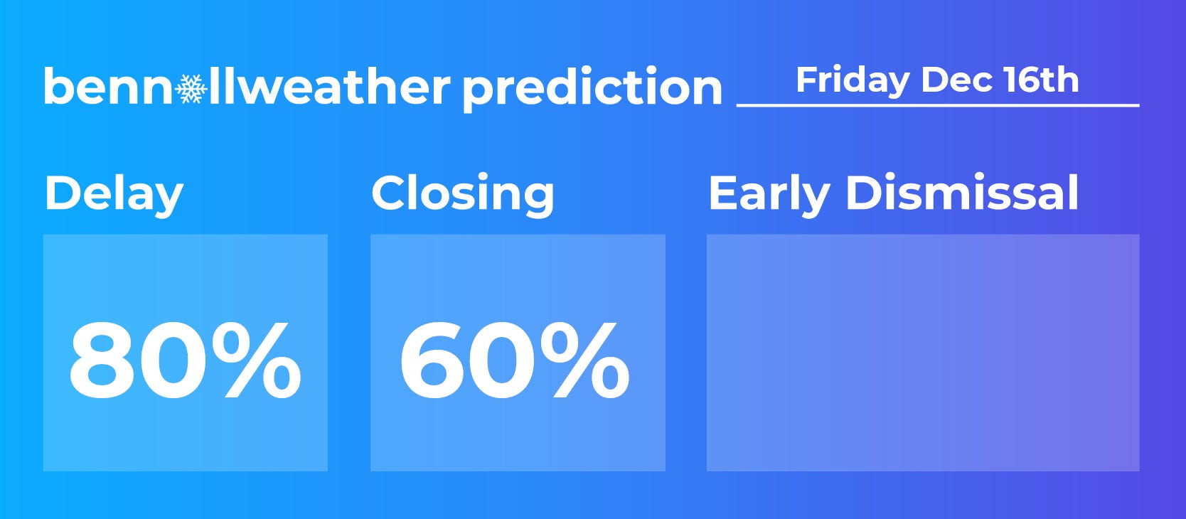
Twitter is bound to be a hive of activity when I release school-by-school delay and closing percentages for Friday around 6:00 pm today (wish me luck 😅).
This is probably my final email update for this enigmatic event. Spare a thought for your local superintendent!
Catch you soon ✌️