Snow-free February? Close call!
Update #537
Greetings everyone! Hope you’re enjoying Februapril 🤷♂️
The week ahead will be less “April-like” than last week — no 60 degree temperatures are in the forecast. Still, having only two days with high temperatures in the 30s is quite a feat for the time of year.
The snow drought has really ratcheted up as we are still without measurable snow this month. We even eked out an inch during February in the non-winter of 2001-02.
There are a few chances this week — Tuesday morning, Thursday evening, and Saturday — but, consistent with our experiences so far this winter, none appear to be a slam dunk.
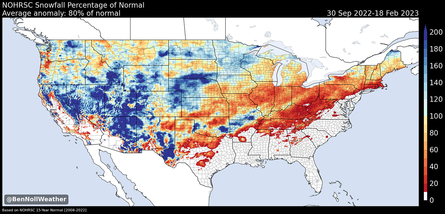
The map below shows snow as a difference from normal so far this season. The red colors (🔴) in our corner of the country indicate accumulations that have been well below normal. But I guess you didn’t need a map to tell you that!
Here’s how the next week is looking… a bit topsy-turvy 🎢
Monday could well be the pick day of the week — there won’t be a ton of sun, but it looks mild
A disturbance Tuesday could bring some wet snow early and rain, but recently warm temperatures means that if it does snow, it will have a tough time sticking to warmer surfaces
Wednesday will start cold and dry, but another weather system will approach late in the day, possibly starting as snow or sleet, then changing to a cold rain
There’s some uncertainty with precipitation type — if cold air manages to hold on for longer, it could spell an icy mix on Wednesday night
The bulk of the precipitation will have probably departed by Thursday, but a few showers may linger. The temperature forecast is pretty uncertain, because a much warmer air mass to the south will battle with a cold one to the north.
Friday is looking dry but cold and breezy — wintry vibes
On Saturday, an area of moisture is forecast to approach from the west, but a lot of dry air in the atmosphere could prevent it from causing accumulating snow — watch this space…
Sunday’s forecast is rather uncertain and things might change, but it’s currently looking milder than Saturday
If impactful, wintry weather threatens, you’ll hear from me again.
During the week of the 27th, things are looking fairly unsettled. With enough cold air hanging around, as shown in the visualization above, we might be looking at some early March snow! ☃️
🔮 For more about the types of weather patterns that we’ll have this coming spring, check out my premium post.
Cyclone Gabrielle
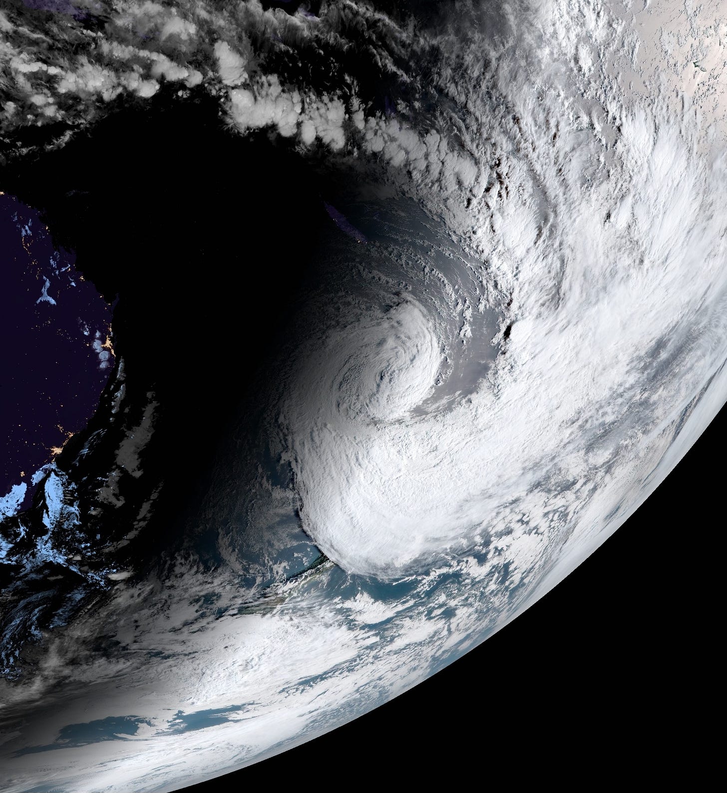
This week, New Zealand was affected by one of its worst weather disasters in modern times: Cyclone Gabrielle. It was New Zealand’s version of Hurricane Sandy, from both a predictive and impact perspective.
For context, in the Southwest Pacific, hurricanes are called “tropical cyclones” — these storms have a different name depending on which part of the world they form in, but tropical cyclones, hurricanes, and typhoons are the same thing. Sometimes they reach New Zealand, but not before their characteristics have changed because of movement over cooler sea water, similar to a remnant tropical system affecting the Hudson Valley.
However, their interaction with other weather systems in the region can lead to a reintensification. And reintensify Gabrielle did…
On the night of February 13th, Gabrielle became one of the strongest storms to ever track into the New Zealand region, passing just offshore of the northern North Island.
For over a week, forecasts had ominously shown this cyclone dropping southward and swiping the country. The track wobbled slightly left and right, but the overall message remained the same — brace for impact.
On the morning of February 14th, residents in the northern North Island awakened to carnage. Believe it or not, those were the “lucky” ones — the ones who could pick up the pieces afterward and didn’t have their lives turned upside down. Despite the advance warning, those living in the eastern half of the island were abruptly awakened by river floods that were likened to a tsunami, decimating entire towns, tossing power poles as if they were toothpicks, and ravaging agricultural and horticultural lands. It was unlike anything that had been experienced by the current generation of New Zealanders, where grass fields turned to raging torrents in just 30 minutes.
There is a story of about 500 residents from a small, rural community seeking refuge on a hill while floodwaters rose all around them. Stories of people walking for over 24 hours straight in search of help. Because of a lack of power and internet, thousands remain uncontactable. The death toll stands at 11, but there are fears it will continue to grow.
This little blurb on the storm hardly does it justice. The recovery will take years.
Gabrielle, in pictures.
Be well this week ✌️


