Finally, snow! ☃️
Update #538
Hey there! It only took until the *very end* of meteorological winter, but finally, accumulating snow is on its way 🔜 🌨️
Better late than never, right? 😅
Our biggest accumulating snowfall of the season is forecast to arrive on Monday evening and last into Tuesday. I’m also watching Friday for a possible storm.
Given the disappointment of the season so far, I don’t want to go so far as to promise a snow day just yet, but things are looking quite good ☺️
In fact, things are looking good enough to trot out my brand new snow day meter! I was going to wait until next winter, but what the heck…
As of early Sunday morning, the National Weather Service had issued a Winter Storm Watch for Orange, Ulster, and Sullivan. I expect these bulletins to expand into other counties over the coming day.
What? Snow, heavy at times
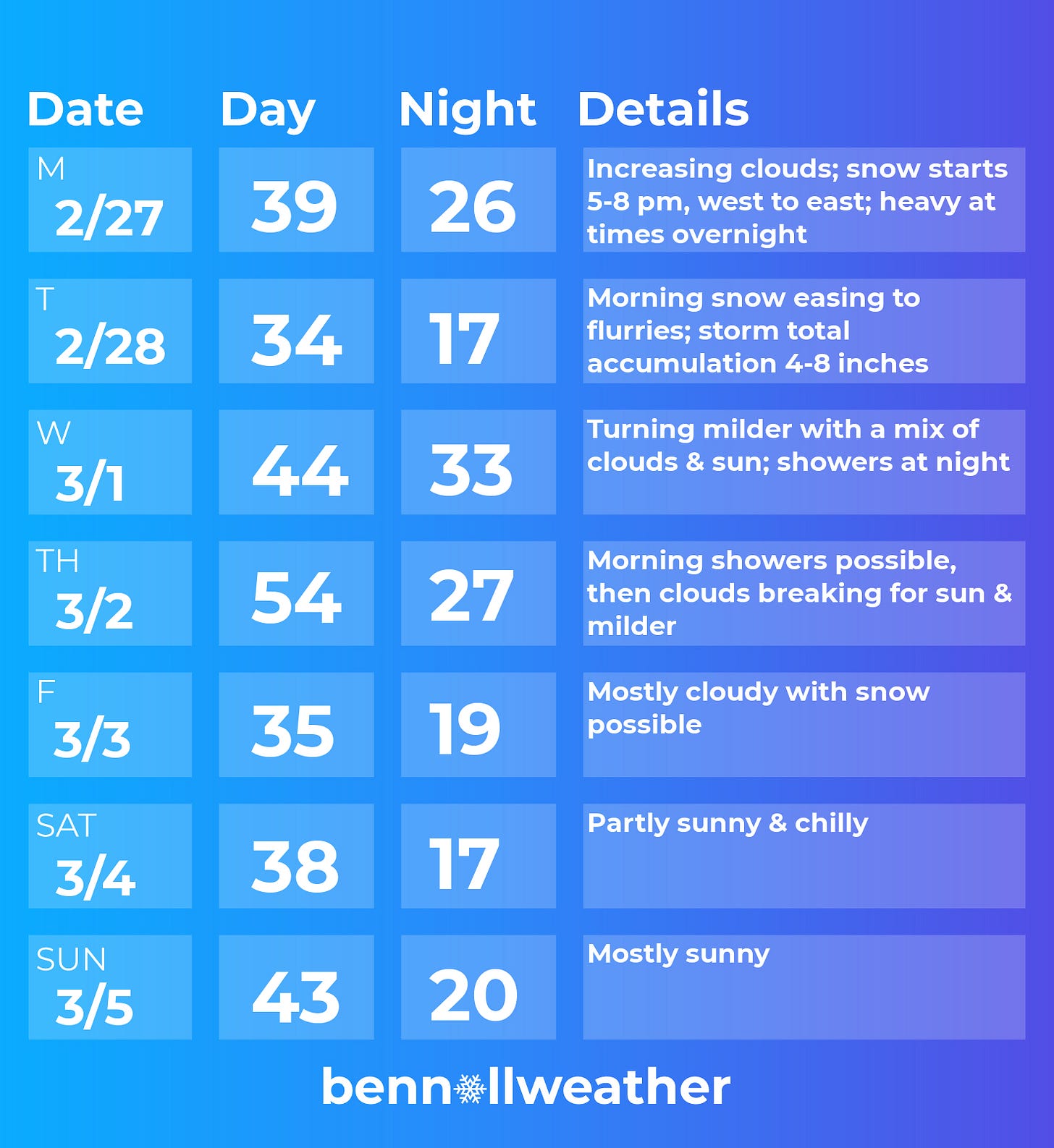
When? Starting from west-to-east on Monday evening between 5:00 - 8:00 pm; the start time has been trending later
How much? 4-8 inches across the Hudson Valley and Catskills, with the highest amounts in Orange, Ulster, and Sullivan. Recent forecasts have been trending toward more snow and little or no ice.
Impact? A widespread, plowable snowfall is looking likely right across the region. Should the timing hold, snow won’t get underway until the end of the evening commute on Monday. After school activity cancellation on Monday is therefore more likely than early dismissals. The bulk of the snow will fall on Monday night when snowfall rates may reach over an inch per hour, leading to snow-covered roads and very treacherous travel. By the time school decisions are made early on Tuesday morning, it may well look like a winter wonderland out there. Snowfall intensity will wane on Tuesday with an additional inch or two possible before noon, but much of the morning will be spent cleaning up what fell overnight and hopefully making snowmen — a classic “snow day” at long last ☃️
My Twitter will become the Hudson Valley “snow day prediction center” in the coming days. Stop by for the forecast and fun!
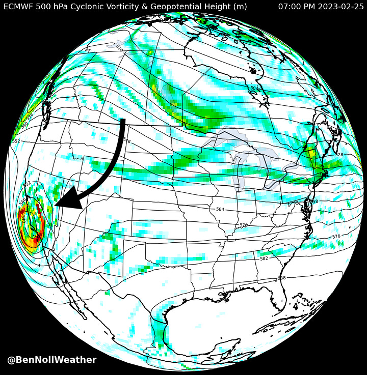
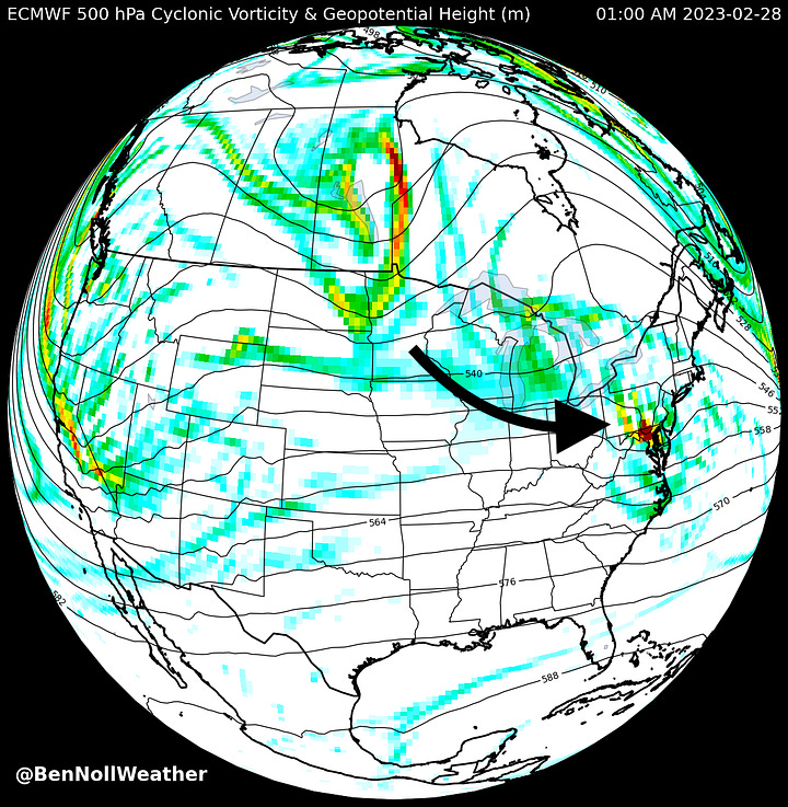
The storm currently bringing very low elevation snow to Southern California is the same one that will be in our backyard on Monday night, as shown in the images below.


A proper March weather roller coaster will follow 🎢
Milder temperatures on Wednesday will be followed up by rain showers from Wednesday night into Thursday morning. On Thursday afternoon, there’s a chance that temperatures rebound into the 50s, but still some uncertainty.
Colder air will then track into the region on Thursday night, potentially setting the stage for the second winter storm of the week on Friday 👀
You’ll definitely want to keep tabs on the possible Friday storm. I’ll have more to say about it as the week goes along and details crystallize.
At this point, any storm on Friday doesn’t look like it will stick around into the weekend; Saturday looks relatively chilly before temperatures bounce back on Sunday with dry conditions.
Looking ahead to the week of March 6th, it may start on the mild side before turning colder. And we may not be done with snow either 😬
Premium subscribers will learn more about that in the March climate outlook, which continues below ⬇️
(if you prefer your weather with an extra side of nerdiness, this is for you! 🤓)
Have a wonderfully wintry week, even if it is meteorological spring ✌️


