
Snow update! ❄️
Update #538a

It’s coming. To all those who have worn pajamas inside out, flushed ice cubes down the toilet, and done a snow day dance, your efforts will finally come to fruition. Nice work! This one is for you 💯
You know what shirt to wear today 😁

What separates this storm from some of the other duds we’ve had this year is the temperature. When the snow starts to fall on Monday evening, the temperature will drop into the upper 20s across the region, allowing the snow to stick and accumulate on all surfaces.
⚠️ As of early Monday, the National Weather Service had upgraded its watches and advisories to warnings for the whole region except for Dutchess (where an advisory remains in effect), running from Monday evening into Tuesday afternoon.
What? Snow, heavy at times Monday night, then light to moderate on Tuesday
When? Starting from west-to-east on Monday evening between 6:00 - 9:00 pm; ending mid-to-late afternoon Tuesday

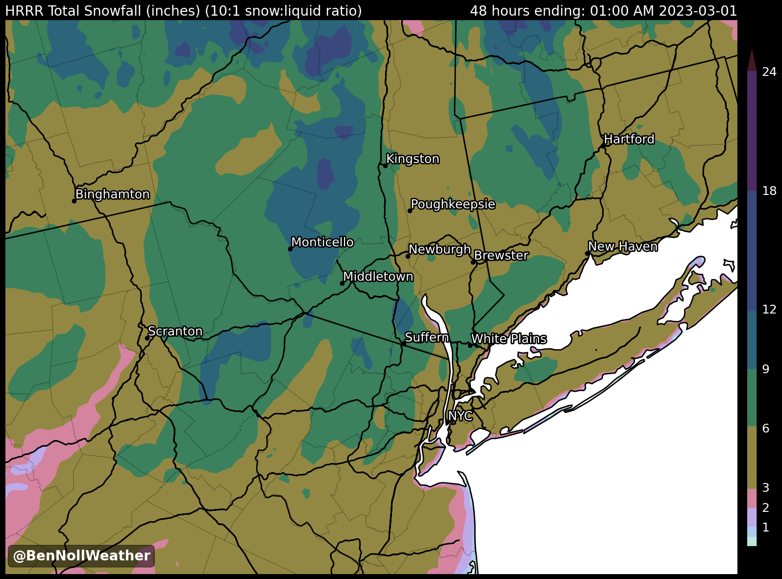
How much? 4-8 inches. The highest amounts are expected in Orange, Ulster, and Sullivan.
The map below shows modeled snowfall distribution across the Hudson Valley — the green colors indicate where 6 or more inches may fall. I think the amounts may be a bit heavy handed, but the placement of the highest totals over Orange, Ulster, and Sullivan seems accurate.
Impact? Get your snow blowers and shovels ready! We’ll be digging out from a decent snowfall on Tuesday. Snow won’t get underway until after the evening commute on Monday. Early dismissals are not expected, but after school activities taking place after 6:00 pm should be cancelled. The bulk of the snow will fall on Monday night when snowfall rates may reach over an inch per hour, leading to snow-covered roads and very treacherous travel. By the time school decisions are made early on Tuesday morning, it will likely look like a winter wonderland out there. While snow rates won’t be as heavy during the day on Tuesday, sub-freezing temperatures during the morning will allow another inch or two to accumulate.

I will issue school-by-school closing predictions on Twitter around 6:00 Monday. Feel free to stop by and enjoy the show and then the snow! ☃️
PS — I am continuing to monitor another storm threat for Friday-Friday night. The responsible disturbance will move into California on Wednesday, which is when Friday’s forecast details for the Hudson Valley should begin to crystallize. As of now, the snow risk increases during the second half of the day. Stay tuned!
I LOVE BENNOLLSAYS!!!! Thank you!