
💧 Summer of rain & wildfire smoke 💨
Update #558

I wish I could say it would turn into the summer of sun this coming week, but it isn’t to be.
First it was the Sunday flash flood. Then it was the non-stop lightning storm on Thursday night. Early Sunday morning, there was another tropical deluge, with additional rain and thunderstorms likely in the afternoon.
These three events resulted in over a summer’s worth of rain in just a week for some parts of the region and will likely culminate in one of (if not the) the wettest months of July on record.
Come on Mother Nature, we need a break!
This twitter thread discusses some of the “why” behind the “wet” 👇


I wish I could say otherwise, but we’ll remain stuck in a rut of relentlessly wet weather for at least a week more.
Although Monday looks dry, another unwelcome guest will make a return visit our skies (it pains me to say): wildfire smoke 💨
The smoke looks to be low enough to the ground to cause a reduction in air quality starting Monday afternoon and is expected to last through Tuesday.
The image below shows the smoke coverage and extent across the country through next Thursday. For an animation, follow this link.

The smoke probably won’t be in the air all week, with Wednesday showing an easing in concentration. It’s not saying much, but I guess it’s better than the 130˚F expected in Death Valley, California on Sunday?
Any way you slice it, it’s another week of dodging rain drops and campfire air:

Monday: dry but humid with increasing wildfire smoke 💨
Tuesday: smoky and humid with afternoon and evening showers and thunderstorms, some heavy ⛈️
Wednesday: still humid but probably dry 🤞
Thursday: PM thunderstorm chance…
Friday: humid with the potential for heavy thunderstorms due to another tropical air flow ⛈️
Saturday-Sunday: the tropical air mass could linger into Saturday, keeping the chance for heavy rain in the forecast; Sunday is looking better at this point…
For the week of the 24th, there’s a bit of good news — a signal for higher than normal pressure emerges over the Northeast U.S., which should temporarily quell the constant downpours. Let’s hope the signal sticks.
Oh, before I go, here’s the 10-day humidity chart:
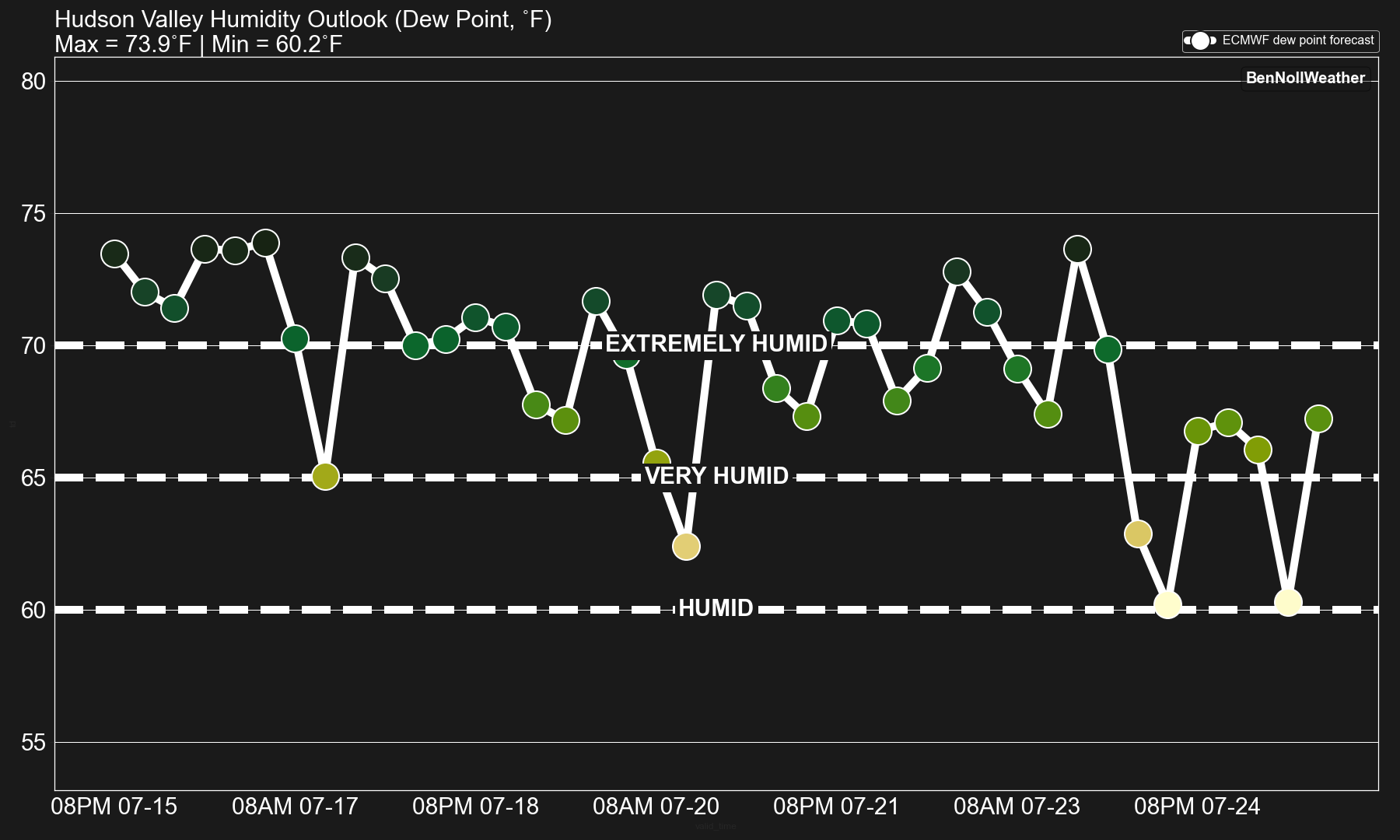
…just another week in the Hudson rainforest 🦎
Make it a good one! ✌️
I was contacted by the Associated Press for comment following last Sunday’s extreme rain event. Here’s what I wrote in response:
Although I'm based in New Zealand, I grew up in the Hudson Valley. While the heavy rain event and likelihood of flooding was well-predicted at a regional scale, owing to a plume of tropical moisture in the atmosphere, predicting exactly which town(s) would experience extreme impacts remains a forecasting challenge. On Sunday, it just so happened to be eastern Orange County, a mountainous part of southern New York in the Hudson Highlands. The impacts highlight our vulnerability to extreme weather - there are no havens when it comes to weather extremes and it's not going to get easier as we go into the future. We need to build back better, stronger, and in a more resilient fashion where possible.
The intensity of the rainfall (radar estimates of over 10 inches of rain in less than a day, almost a summer's worth in some spots) reminds me of some of the intense falls experienced in New Zealand over the past year, dealing with frequent cyclones, atmospheric rivers, and a marine heatwave. I feel for those affected and can understand their plight.
A warmer atmosphere can hold more water vapor and ultimately the events that occurred in the Hudson Valley on Sunday may have been made more likely or worse because of it:
The air mass that has been affecting the Hudson Valley is connected to a reservoir of heat and moisture originating in a marine heatwave-affected Atlantic Ocean:

You may wish to read my latest premium post, which discusses in detail how the Hudson Valley’s climate is changing and the types of weather that may become more (and less) frequent in the future.
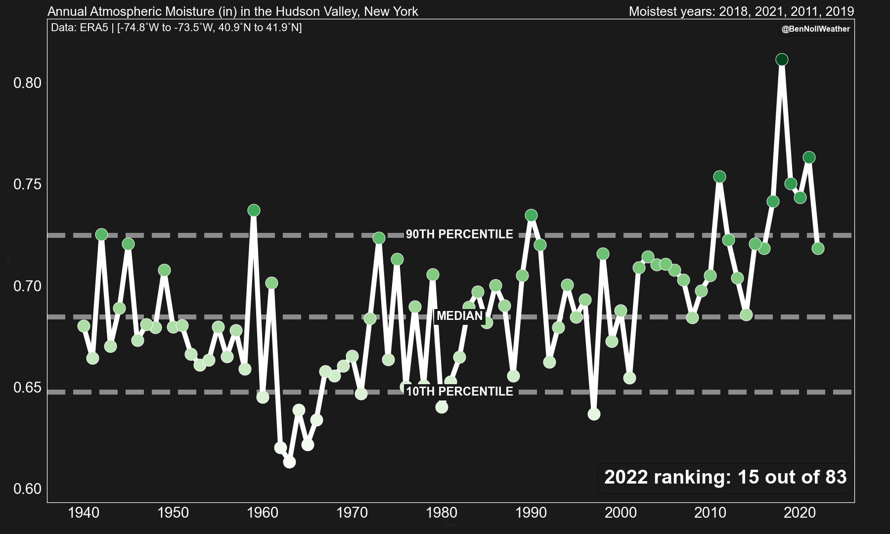
A climate change dashboard for the Hudson Valley

I’m pleased to share a brand new climate resource for Hudson Valley educators, farmers, growers, long-term planners, policy-makers, and anyone who is interested in tracking our changing climate. This is a project I’ve long wanted to embark on to provide some baseline information for our region. The process is largely automated, such that every year I’ll be able to run a script by around January 10th that summarizes the climate over the last year and
It's as green as The Emerald Isle of Ireland itself here in the Newburgh area. Had to water my grass seed most of May and I lost some of it from the dry heat of June; now, my lawn is like a safari! Thank you for the excellent weather forecasting. Hard to believe half the world is in winter.