
Calm corner of the country, for now
Update #563

Greetings! 👋
10 of the first 19 days of August featured measurable rainfall in the Hudson Valley. In July, 16 out of 31 days featured rain.
We’re due for a stretch of drier weather!
So while a heatwave scorches the Plains, a tropical storm hits California, and rain drenches southern Texas, our corner of the country will be the calm one — at least to start the week.
Mother Nature likes to balance things out.
Hilary hits California
Tropical moisture from Hilary is streaming into California and the Desert Southwest this morning, a highly unusual occurrence for the time of year. Destructive flash flooding and significant damage is likely in Southern California from this once category 4 hurricane as over a year’s worth of rain falls in some areas. Moisture from Hilary will find its way into places that frankly have little or no experience dealing with “tropical” weather — Nevada, Oregon, Idaho, and Montana! This won’t be a storm that the west soon forgets.

In the Hudson Valley, we won’t have much in the way of rain until later in the week. Remnant moisture from Hilary will actually be a contributing factor, taking a big loop around a massive dome of high pressure in the central states.
The unusual nature of the pattern is being influenced by a significant jet stream anomaly, with a major dip in the west.
Here’s how it’s looking in our neck of the woods:
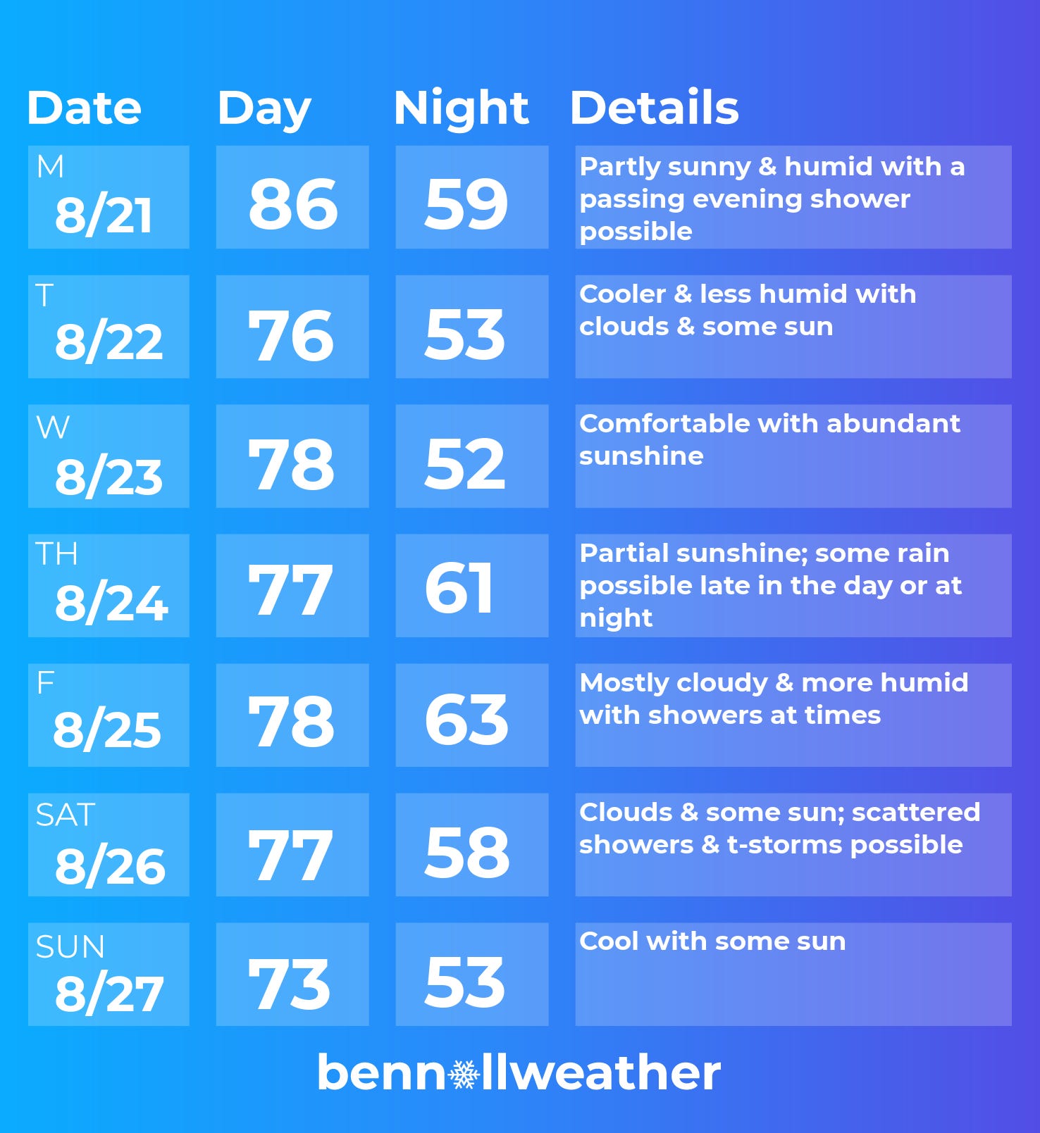
Monday: humid with mix of clouds and sun, chance for a passing evening shower
Tuesday: much cooler and less humid, morning clouds giving way to afternoon sun
Wednesday: sunny and nice 🥇
Thursday: increasing clouds; some rain is possible later in the day or at night
Friday: more clouds, showers return
Saturday-Sunday: wet weather may continue on Saturday while Sunday features a drying trend. Sunday is not a lock to be dry at this point, so keep an eye on things if you have plans.
It’s looking quite cool about a week from now as air filters down from northern Canada 🍂
Looking ahead to the week of the 28th, we’ll be keeping an eye on the tropics. There’s three disturbances, denoted by the white arrows in the image below, that are worth watching for development.

The westernmost storm could track close to the eastern seaboard around the end of the month…
One thing is for sure: the end of August and beginning of September isn’t looking hot!
With meteorological fall and the start of school just around the corner, you might be starting to think about snow day season! Last week, I published a premium post “Five maps you should see about next winter” 👇

No matter the weather, I hope your week shines bright ☀️
Perfect forecast for the Hudson Valley! Thanks Ben! Stay Safe🥰