Clear skies in time for turkey day 🦃
Update #576
☀️ The good news is that the wider Northeast can expect a dry turkey day. However, I trust that your cooked turkeys will turn out wonderfully moist! 🍗
Thanksgiving Day sunshine will be preceded by some unsavory weather late Tuesday into early Wednesday, in the form of a cold rain storm for the Hudson Valley.
Those living in the Catskills, particularly above 1500 feet, will probably be greeted by some wet snow! ❄️
For that reason, I am moving the “snow day” needle to a 1 out of 10 this week with a slight chance for early dismissals in the Catskills on Tuesday, though at this point precipitation looks to hold off until after 5:00 pm.
By Wednesday morning, the storm will likely be clearing to the east, with decreasing clouds and increasingly favorable travel conditions.
Although it will be crisp and frosty on Thursday morning, it’s no 1989. That’s when the low temperature was 9˚F and 3 inches of snow fell on Thanksgiving Day.
At any rate, hopefully the warmth of family and friends around the Thanksgiving dinner table will more than make up for Mother Nature’s cold shoulder 😁
A cold front tonight (Sunday night) will set the stage for a chilly start to the week…
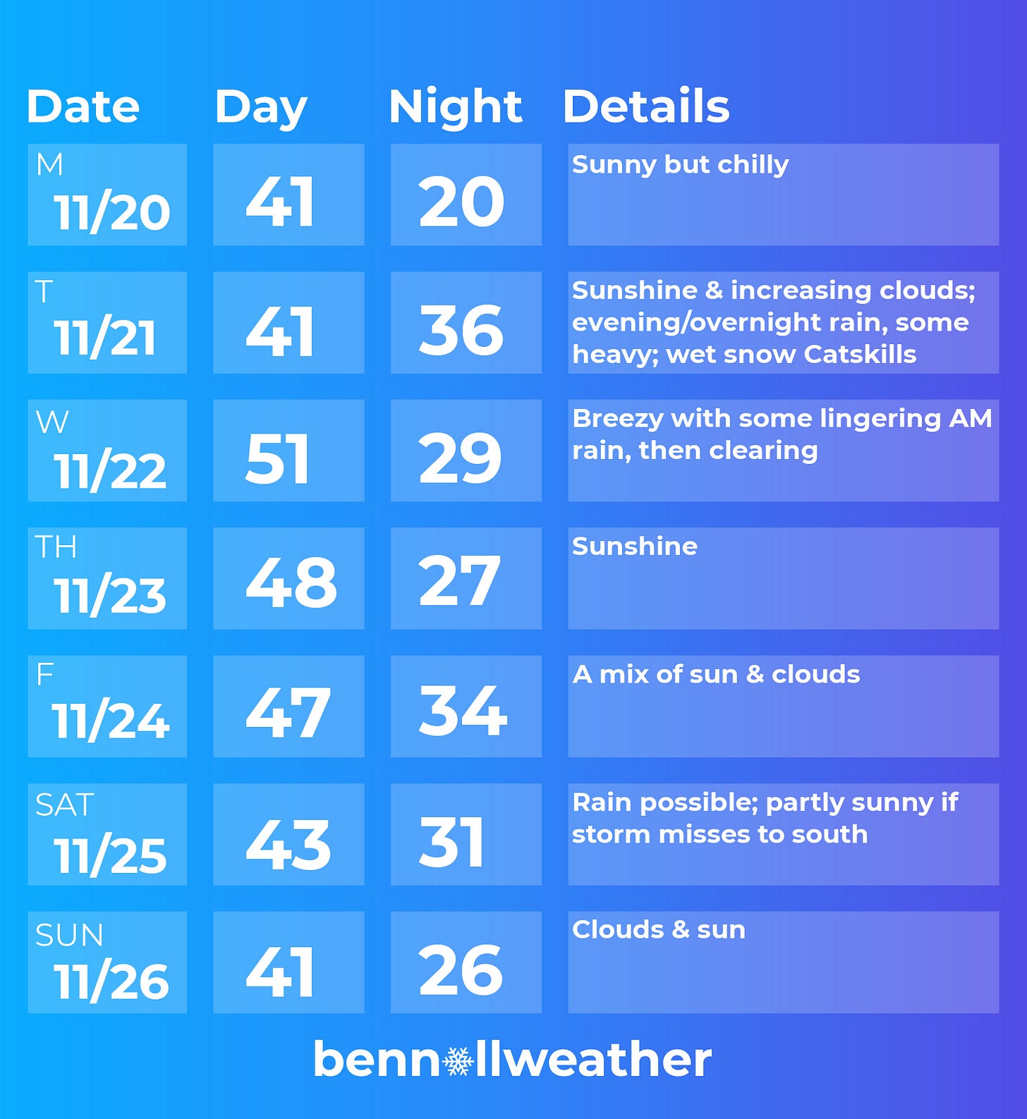
Monday: a chilly but sunny start to the week
Tuesday: some sun to start, then increasing clouds with rain arriving in the evening and continuing overnight, heavy at times 🌧️ — wet snow changing to rain in the Catskills 🌨️
Wednesday: breezy with some lingering rain possible early, then clearing
🍽️ Thursday: a crisp start but pleasant finish — Mother Nature saves her best for Thanksgiving! 👏
⚫ Friday: likely remaining dry and sunny, similar temperatures to Thursday
Saturday-Sunday: a coastal low pressure system may bring some rain on Saturday or miss to the south with partly sunny skies; looking dry and cool on Sunday at this point
The week of November 27th is worth watching for some wintry weather. It looks like some cold, Canadian air may flow southward, fueling the development of a storm track. I’m keeping an eye on the mid-to-late week period in particular — stay tuned! ❄️
➡️ On Saturday I released a winter outlook update video, focusing on a spell of cold air that may affect the region during the week of November 27th and what December-February are looking like. If you are wondering when the first snow day might be, it’s a must watch!
Cool clouds ☁️
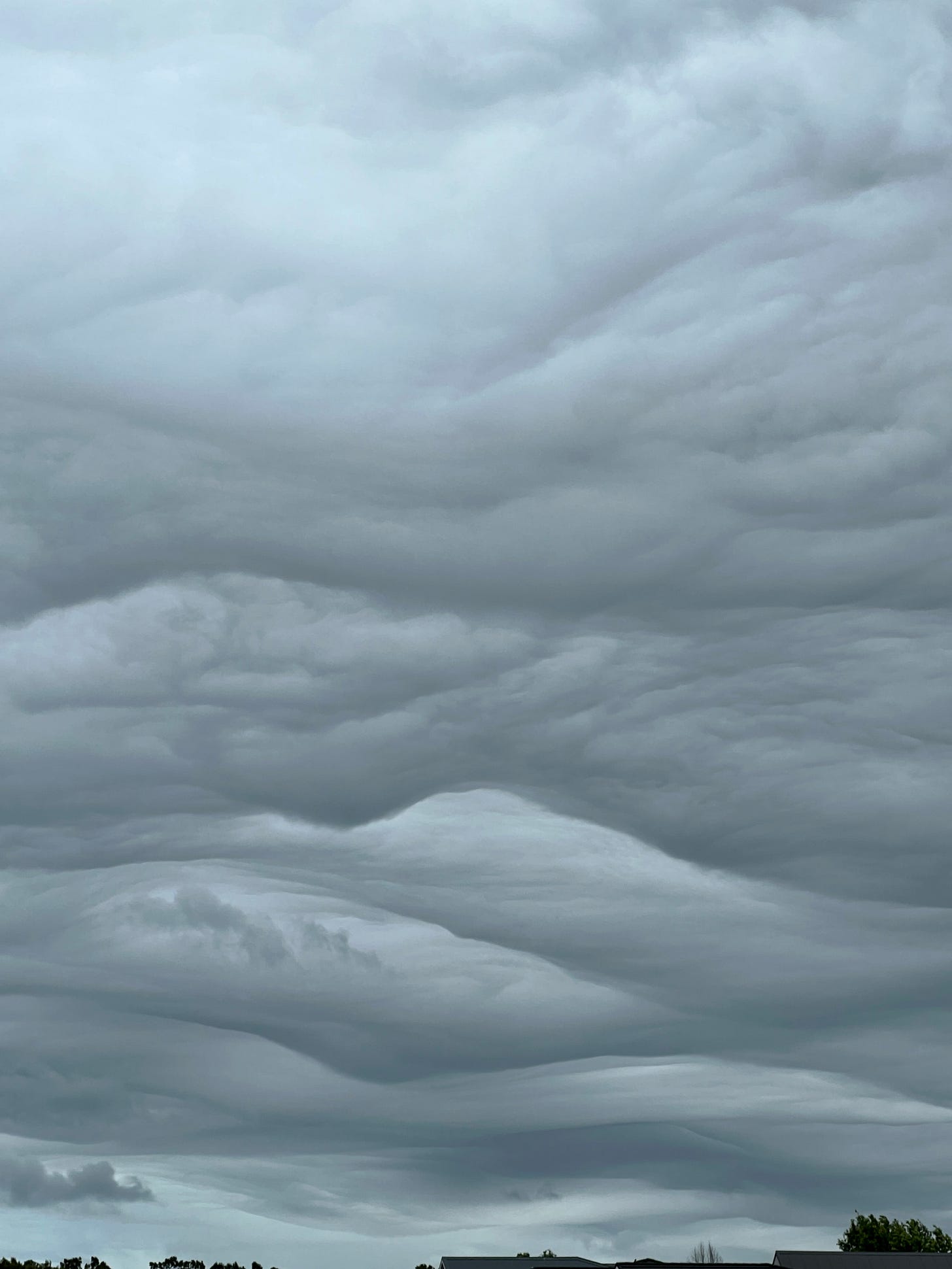
Auckland was treated to some cool clouds on Friday. Have you ever heard of or seen asperitas clouds? Asperitas is a newly classified cloud formation, officially recognized by the World Meteorological Organization in 2017.
They are relatively rare wave-like clouds, typically forming in an unstable atmosphere with heavy showers and/or thunderstorms, and characterized by their undulating, turbulent appearance, often resembling the surface of a rough sea.
Check them out!
Here’s a time-lapse video 🎥
Whatever the weather, may your week be filled with warmth, happiness, and good food. I’m thankful for you all ✌️


Thank you Ben! Have a wonderful Thanksgiving 🦃