
New year, new weather pattern... eventually! ❄️
Update #582

Happy New Year! 🎇
After a mild December, Mother Nature is turning the page. The next chapter hasn’t been written completely, but judging by the first few paragraphs, the words “cold” and “snow” are more common. The polar vortex is awakening.
Contributing to the change is something called a “Sudden Stratospheric Warming” event, SSW for short, that is expected to disturb the polar vortex. The polar vortex, which involves strong winds that encircle the Arctic keeping frigid air locked up near the North Pole, is forecast to weaken, allowing icy air to escape from the pole toward the mid-latitudes like the U.S. and Europe.
Every SSW event is unique: where the coldest air focuses and how long it takes to arrive are questions yet to be answered. Sometimes it’s Europe that bears the brunt, sometimes North America, and sometimes both.
The first image shows the current state of the polar vortex — strong and focused over the North Pole, as indicated by the purple coloring there. The second image shows the predicted state of the vortex in early January, displaced, elongated, and infiltrated by warmer air on its western flank.


At any rate, we probably won’t be feeling the effects of the SSW until later in the month, as it takes time for the pattern to propagate downward from the stratosphere to the troposphere where the weather happens.
For now, we watch and wait. SSW or not, January is our coldest month of the year, so cold and snow is to be expected.
At the end of this post, I’ll offer my thoughts on possible windows of wintry weather to premium subscribers.
❄️ For the week ahead, there are a few chances for snow! A few flurries could help ring in the new year, a coastal storm will likely pass south of the region on Thursday, and then a nor’easter may track near the region on Sunday.

Monday: a few flurries may fly early; otherwise, plenty of clouds
Tuesday: lots of sun — the pick day of the week 🏅
Wednesday: dry but with increasing clouds
Thursday: a coastal storm will likely pass to the south of the region but a few flakes can’t be ruled out
Friday: a cold, frosty morning but with plenty of sun 🥶
Saturday-Sunday: dry weather is expected on Saturday, but a nor’easter could track near the region on Sunday, bringing a chance for wet snow! 👀
The lines on the plot below indicate 50 different possible locations for Sunday’s storm. There’s a clear preference for it to be near the East Coast, but its exact location and strength (shown by the color of the line) are up in the air.
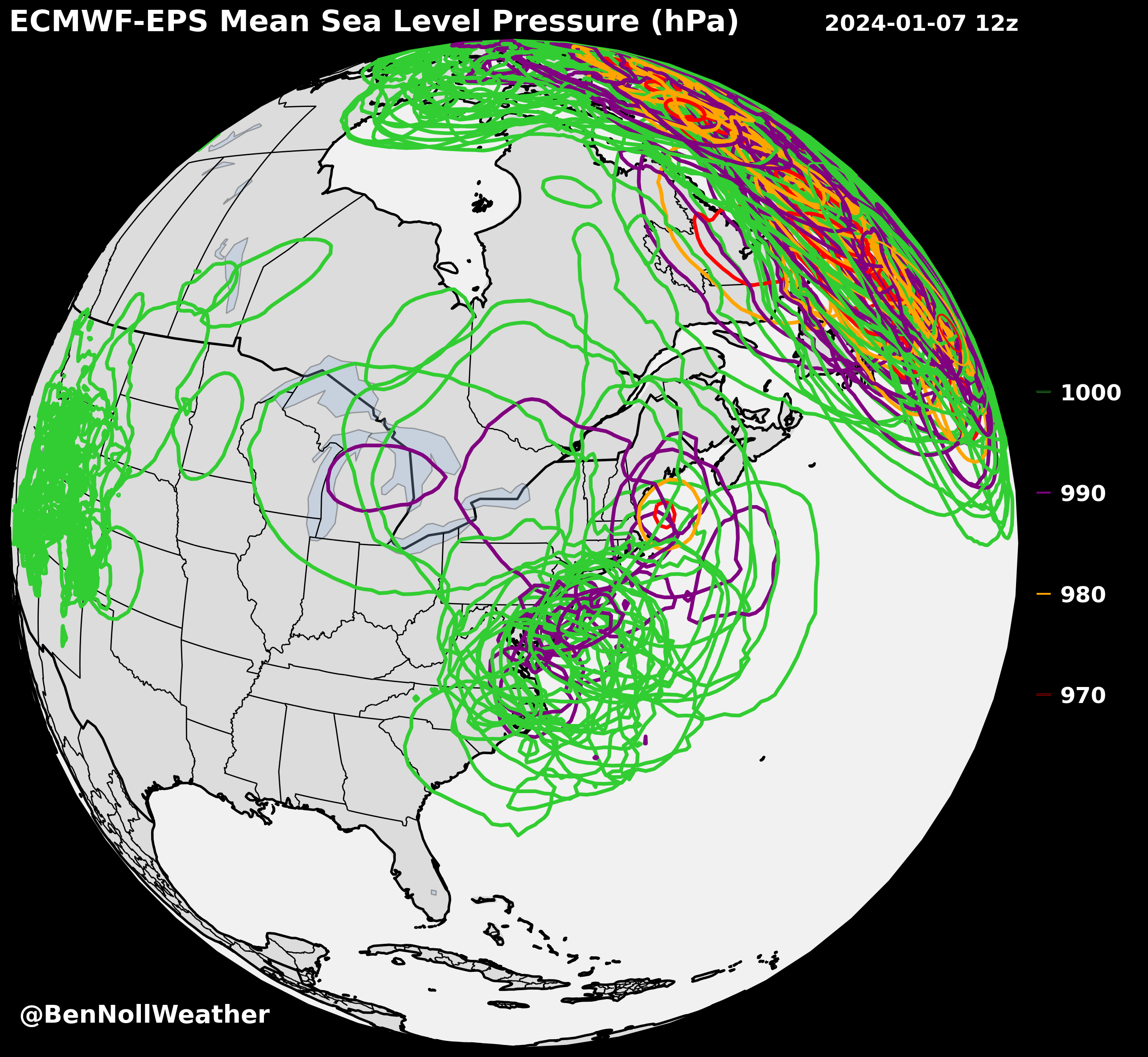
I’ll be in touch as the forecast for Sunday becomes more certain. Of course it lands on a weekend! 🤷♂️
Looking ahead to the week of January 8th, I’m watching for two more storms. Premium subscribers can find out what days I’m specifically monitoring at the end of this post 😁
The sun sets on 2023 in New Zealand 🌇 — a wild year for the weather here…
Thank you for following along this year! The weather connects us all. May your 2024 have a bright start ✌️
Premium subscribers, read on for my thoughts on possible windows of wintry weather into mid-January.
