Mild end to meteorological winter 📈
Update #590
For the first time on record, dating back to the 1940s, February will come and go without having a single sub-freezing high temperature in the Hudson Valley.
You read right: the region didn’t experience a single day this February on which the high temperature was below 32˚F.
Such occurrences will become more common as our climate continues to warm.
Speaking of warmth, the week ahead is looking more like early April than late February, temperature wise. The average high temperature this time of the year is in the low 40s, but most days this week will be 15-20 degrees warmer than this.
Meteorologically speaking, spring arrives on Friday. The astronomical definition has it arriving this year on March 19th. For more on the types of weather the region can expect in the new season, check out my latest premium post “Seven maps you should see about spring 2024”.
Seven maps you should see about spring 2024
Meteorological spring, March 1st, is less than a week away! Meteorological seasons start a little earlier than astronomical ones. In the case of spring, it’s March 1st vs March 19th. Why the difference? Well, quite simply, it makes for easier record-keeping and combines the months with the most similar temperatures.
➡️ Snow days aren’t looking likely this week, but on Monday morning, there’s a chance for a passing, light wintry mix around the time of the morning commute. It doesn’t look like much, but it’s something to keep in mind. Temperatures will quickly rise above freezing, helping to limit the impact. Then, on Wednesday night, a strong cold front will race through the region with temperatures crashing below freezing after midnight. There’s a chance that this could result in a “flash freeze”, although these events are challenging to forecast — strong winds will help to dry out pavement and sidewalks quickly.
Unseasonably mild days in the week ahead are denoted by a thermometer emoji (🌡️):
🌡️ Monday: chance for a passing wintry shower in the morning, then becoming very mild with sun and clouds
🌡️ Tuesday: very mild with a blend of sun and clouds, slight chance for a passing sprinkle
🌡️ Wednesday: windy and remaining very mild with passing showers; rain at night, changing to snow in the Catskills with a coating possible and a slight chance for a flash freeze
Thursday: partly sunny, windy, and colder
🌡️ Friday: sunny and turning milder
🌡️ Saturday-Sunday: looking mild at this point, but a fair bit of cloudiness is possible and even a few showers can’t be ruled out
Looking ahead to the week of March 4th, it’s more of the same — in fact, it could be even warmer than the upcoming week. It also looks like it will turn wetter as the week goes along, thanks to a moist, humid flow of air from the Gulf of Mexico.
Need a new screen saver? Photos from an epic drone flight!
Every time I fly my drone in New Zealand I seem to come home with a new screen saver 😅
Last weekend, Kate and I visited a place called Otama Beach in a relatively secluded part of the North Island.
The road to get there involves hairpin turns and a 700 ft elevation gain over a mile or so. At the top, there’s a makeshift traffic light as the road is down to one functioning lane, the other cascading off the cliff during last year’s cyclone.
After reaching the beach, the white knuckle drive was quickly forgotten, as white silica sand squeaked beneath our feet.
I scoped out my drone launching spot: an isolated, rocky corner of the beach, as pictured below.
There was enough sunlight to create the quintessential tropical beach scene with turquoise water.






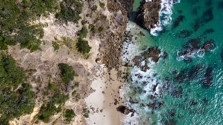

My favorite photo of the day, and new screen saver, came as I pushed the drone nearly a kilometer offshore and pointed the camera back at the beach.
A truly majestic view.
In case you want to see how it would look as your screen saver, you can download the full resolution photo at this link 😊
Happy Februapril! ✌️


