
Springing forward: becoming warmer & less rainy 🐦⬛
Update #592

Good day! The clocks sprung forward one hour early this Sunday morning and so will the weather this week: warmer temperatures are bound for the region starting on Tuesday after a chilly, very windy Sunday night (when a flurry may fly ❄️) and Monday.
Tuesday-Thursday look warm and generally dry. Some rain will probably return on Friday.
Bird song may double as your morning alarm as spring kicks into gear 🐣
Temperatures during the middle part of the week will reach well into the 60s, about 20 degrees above the average high of 46 degrees.
On Wednesday, the sunset will occur after 7:00 pm. It will stay that way until the second half of September! 🌇
Despite Sunday night’s possible flakes, snow days are not expected this week. Read on to see if I think snow is done for the season or if there’s still a chance.

Monday: cool and very windy 💨💨 ~ High Wind Watch
Tuesday: mostly sunny and milder 📈
Wednesday: partly sunny and warm 🌡️
Thursday: a mix of clouds and sun and quite warm — if clouds aren’t much of a factor, it could reach 70 🌤️
Friday: mostly cloudy with a period of rain or showers possible, mainly later in the day and/or at night
Saturday-Sunday: both days have a chance for passing showers, but the number of dry hours will likely outnumber wet ones
Looking ahead to the week of March 18th, a surge of colder than average temperatures appears bound for the region 🎢
It’s not a sure thing, but the chance for accumulating snow will increase during the final 10 days of the month.
➡️ Next weekend, premium subscribers will receive a video about the long-range outlook and what I’m watching for summer and hurricane season! To become a premium subscriber, click the button below.
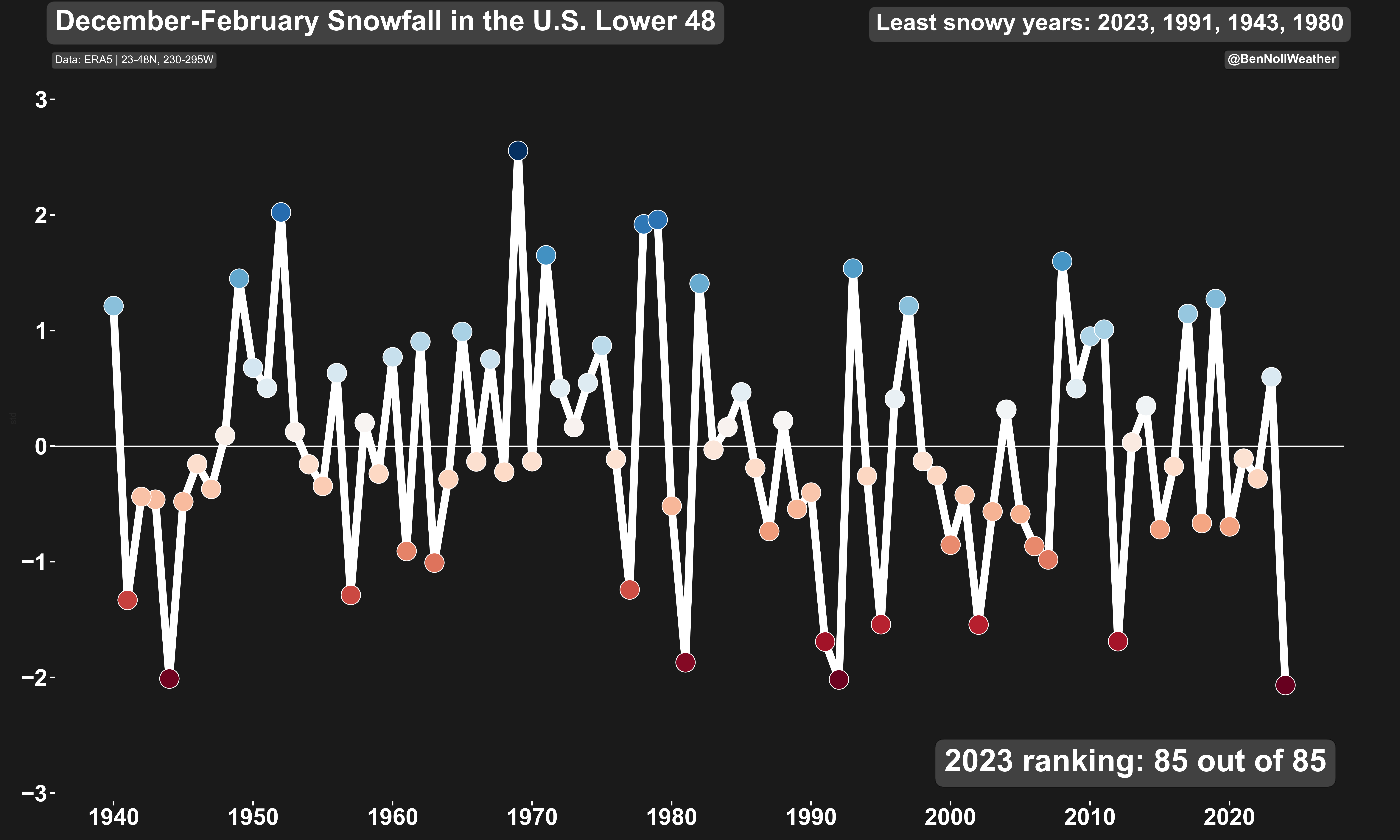
While we’re on the topic of snow, winter 2023-24 (December-February) was the least snowy winter on record for the lower 48 as a whole. El Niño, record warm global ocean temperatures, and warming air temperatures are behind it. El Niño caused a stronger sub-tropical jet stream which flooded the continental U.S. with mild, Pacific air masses.
AI weather model outlook
In last week’s newsletter I shared information about a new artificial intelligence-driven weather model. It’s already scoring points, having accurately predicted this week’s warm spell over a week in advance.
It is now signalling a chilly end to the month, with temperatures dipping below freezing at times, but not a whole lot of precipitation:

I think it can be quite useful for understanding long-range trends at a glance.
I’ve even integrated this chart onto my website, with 4x daily updates: 10:00 am, 4:00 pm, 10:00 pm, and 4:00 am!
Stay tuned and subscribe for more AI weather plots!

Hope your week is as vibrant as the mid-week weather ✌️