Mother Nature won’t be winning any awards for the weather this week in the Hudson Valley.
It won’t be terrible, with dry conditions likely on Monday, Tuesday, and Friday, but it does leave something to be desired.
I’d say we’ve been “stuck in a weather rut” for months now, dating back to last winter.
Similar to last week, a low pressure system over the central U.S. will become “stuck in the mud” as it tracks eastward, reaching the eastern seaboard from Tuesday night into Wednesday. It’s currently unclear how close the storm will track to the Hudson Valley and how long it will linger — two things that will dictate how much rain the region receives from Tuesday night into Thursday. Another system may approach next weekend, basically a carbon-copy of the one before it.
The persistently pessimistic pattern is linked to the sub-tropical jet stream — the same sub-tropical jet stream that plagued us all winter with soaking rain events. El Niño has been slow to relinquish its dominance as the main global climate driver. This has kept the rainmakers and clouds locked in with few exceptions.
The pattern will eventually flip and to learn more about when that might happen, I’d suggest becoming a premium subscriber — I’ll be sending out my Hudson Valley summer climate outlook before the end of the month.
Monday: some sun to start the week
Tuesday: warm (mid to upper 70s) with some sun and increasing clouds; rain possibly arriving by day’s end
Wednesday: living life on the edge of a storm: showers or rain likely in the Hudson Valley, but how much depends on the proximity to the center of the storm
Thursday: showers possible, mainly early — if the storm pulls away quickly, skies may clear in the afternoon [high uncertainty, stay up to date with this forecast]
Friday: probably a break from the rain, warmer with clouds and sun
Saturday-Sunday: increasing clouds, showers or some rain may return
Looking ahead to the week of May 20th, an unsettled pattern is again indicated. Temperatures look relatively close to average. While there will be some decent days, the region will likely continue to dodge rain drops and be in a sunshine deficit.
The map below shows forecast rainfall over the next 15 days. The Hudson Valley is in the 1-2 inch range with 2+ inch amounts not too far to the south.
A solar storm for the ages
On Thursday, the NOAA Space Weather Prediction Center announced the development of a major solar storm: the sun was hurtling tons of plasma at Earth, called coronal mass ejections (CMEs), which would interact with the Earth’s upper atmosphere in the days ahead. Amazingly, humankind possesses the ability to track these CMEs in real-time and, based on their speed, can estimate when they are likely to reach Earth. NOAA has a very useful website where these features can be monitored.
The animation below shows the puffs of plasma (top) and their velocity (bottom) from this weekend’s solar event. The arrival of the red, pink, and white colors to the small green dot (Earth) correlate to excitement in the sky.
Such events are common, especially during solar maximums like we are in now, but the intensity of this event was uncommon. The level of activity reached a 5 out of 5 on NOAA’s geomagnetic scale and prompted warnings of communication, navigation, and power disruption. The historical benchmark for solar storms is the Carrington Event, which occurred in September of 1859. If such an event happened today, there would be significant, negative impacts.
This weekend’s event, however, offered a dazzling display of the aurora to millions of people around the world. Because of the strength of the storm, the northern (and southern) lights were visible at much lower latitudes than is typically the case. Usually, the lights can only be spotted closer to the poles because the Earth’s magnetic field is stronger there. For many people in the middle and southern U.S., Friday night was a rare opportunity to view the spectacle. It sparkled as far south as Florida! Even the Hudson Valley, which is typically not able to see the aurora, basked in its beauty once the clouds cleared [click here to see photos].
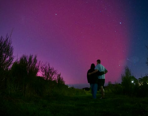
Here in the Southern Hemisphere, anticipation built on Saturday as nightfall was forecast to correspond with a peak in solar storm activity. This opened the door to widespread and vibrant auroras, which could be seen across the full length of New Zealand, even with the naked eye! It was truly an unforgettable night and possibly a once in a lifetime opportunity. Despite a sharp chill in the air, Kate and I tried to make the most of it. It won’t be an experience that I’ll soon forget:


Because the solar storm is ongoing, the Hudson Valley has a chance to see the lights again tonight (Sunday night), although the colors may not be as bright as they were on Friday since the event is in its waning stage.
Have a dazzling week ✌️


