High pressure sets up shop 👌
Update #618
The weather during the week ahead looks pretty spectacular across the Hudson Valley and wider Northeast, as high pressure sets up shop right over our heads.
And this “shop of high pressure” isn’t closing any time soon.
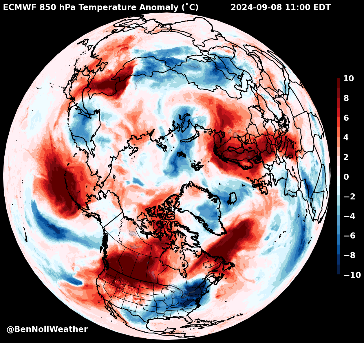
☕ If you’re reading this on Sunday morning, opt for hot coffee rather than the iced stuff — the most unusually cool air mass in the Northern Hemisphere is above the eastern United States 🔵
The potential for a particularly pleasant fall was described in detail in my fall outlook, issued a few weeks ago.
It’s good to see things going to plan! Now onto the much-anticipated winter outlook…
I’ve started to draft my winter outlook and I’m aiming for a release either on October 19th or October 26th. If you want to receive it as soon as it’s available, you’ll need to be a premium subscriber (upgrade your subscription below)!
Where’s the rain?
Moisture will largely be confined to the Gulf Coast and Florida in the week ahead. A tropical storm or low-end hurricane will likely impact eastern Texas and/or Louisiana on Wednesday-Thursday. The next name on the list is Francine.
While heavy rain and flooding could impact the Gulf Coast, the Northeast will be largely shielded from moisture by the big high.
The map below shows current drought areas (gold contours) with an overlay of seven day precipitation — beneficial rainfall from the tropical feature is likely in the south and potentially the Ohio Valley too.
The week ahead
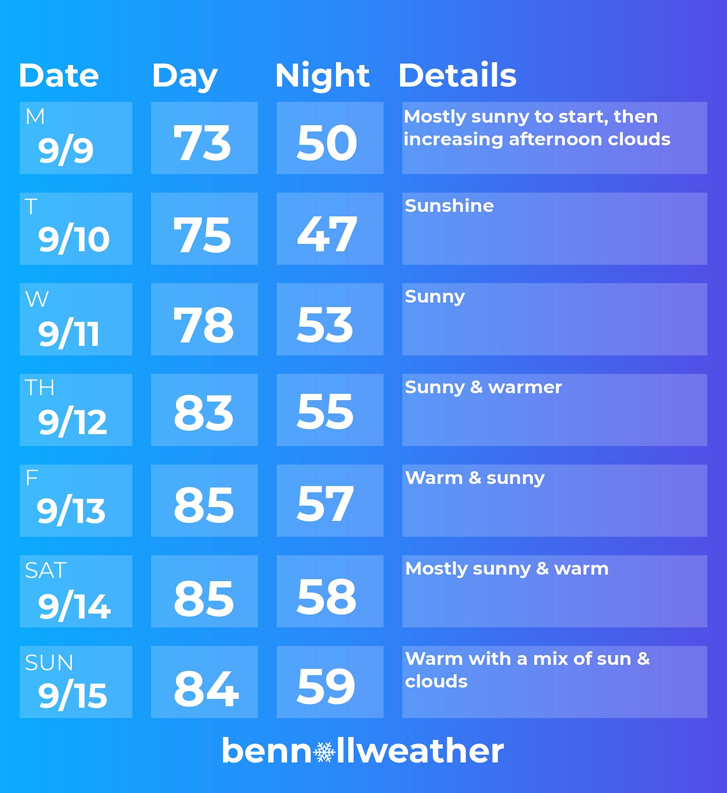
Four words: dry, sunny, and warming up. Easy street for meteorologists.
Monday: mostly sunny and cool during the morning with clouds increasing in the afternoon; an evening shower can’t be ruled out
Tuesday: plentiful sunshine
Wednesday: sunny again
Thursday: warming up into the 80s and sunny
Friday: warm with sunshine
Saturday-Sunday: above average temperatures with mainly sunny conditions
Looking ahead to the week of September 16th, the weather pattern will be influenced by the long-term track of this week’s tropical system. It could fizzle out to the south of the region or bring some moisture early next week.
Looking beyond 🔮
This week, some new seasonal forecast data arrived. It suggests that the dry conditions of September may continue into mid-to-late fall. This is consistent with La Niña-like conditions, which is expected to influence a weaker-than-normal sub-tropical jet stream and lower moisture availability across many parts of the U.S. in the months ahead.
While the mild, dry weather may be welcome now, water-sensitive sectors should have a plan in case the dry spell lasts for several more months.
Hope your week is a 10 out of 10 like the weather! ✌️


Humidity and dewpoints were in the mid 40s last week at Lake Minnewaska, high in the Shawangunk Mountains. Skies were deep blue and there were no bugs thanks to chilly nights. Visibility was unlimited!