Autumn arrives, dry spell to end
Update #620
It’s now been more than 10 days since the Hudson Valley received measurable rainfall.
A tropical disturbance ended up going “wide right” of the goal post this week, sparing the region of rainfall and instead locking in yet more dry weather.
It would appear that the dry spell will come to an end this week as a low pressure system limps through the region on Wednesday-Thursday. However, rain amounts are forecast to be light, with less than half an inch currently possible.
Autumn equinox
Today (September 22nd, 2024) is the autumn equinox! On the autumn equinox, the tilt of Earth's axis is perpendicular to the Sun, meaning that both the Northern and Southern Hemispheres receive nearly equal amounts of sunlight. This results in roughly equal day and night lengths across the planet. The map below shows daylight hours on Sunday, with orange-shaded areas experiencing about 12 hours.
The week ahead
After a dry start and a wet middle, high pressure may return to the region in time for the weekend.
During this time, eyes will be on the Gulf of Mexico, where a hurricane is possible later in the week (next name: Helene). While there’s still some uncertainty as of this writing. the latest guidance shows the storm moving toward western Florida by late Thursday with significant impacts possible, such as storm surge, freshwater flooding, and wind damage. States like Georgia, Alabama, and Tennessee may also experience rain and wind. The exact track will become clearer in the days ahead, but it’s likely to be a noteworthy week weather-wise in the U.S. because of this storm.
The map below shows hurricane “orbs”, with each representing a possible storm location on Thursday evening. Most of the activity is near or just west of Florida.
Farther north, high pressure could “stiff-arm” the tropical disturbance, preventing it from moving into the Northeast — but uncertainty remains, so the weekend forecast may change. For now, it looks good.
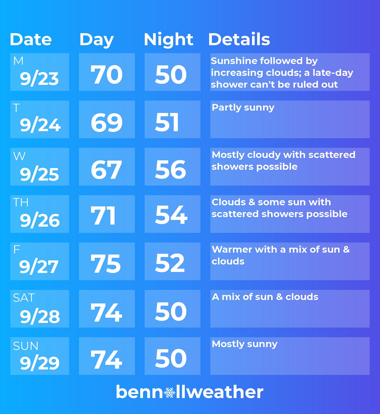
Monday: sunshine, then increasing clouds
Tuesday: clouds and some sun
Wednesday: mostly cloudy with showers possible
Thursday: decreasing clouds, lingering showers possible
Friday: partly sunny and warmer
Saturday-Sunday: remaining warm with a good deal of sun… watching tropical system to the south (forecast could change) 👀
Looking ahead to the week of September 30th, high pressure may continue to be a key player in the Hudson Valley’s weather, with mild temperatures and a general lack of rain.
Snowy scenes 🏔️
Now that autumn is here, that means… winter is next! The past week was rather wintry in New Zealand, with snow falling to unusually low elevations for the time of year. It still shimmers on the mountain peaks, where one of my work colleagues had the pleasure of visiting this weekend. The photos below are from Mt Ruapehu in the central North Island.


My winter outlook is due out in about a month! Upgrade your subscription to premium to make sure you receive it as soon as it drops ⤵️
Score a touchdown this week! ✌️


