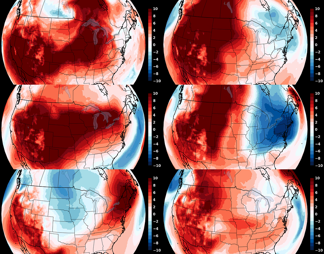
As an unrelenting heatwave creates unbearable conditions in the Southwest and a major hurricane likely heads for Florida, the Northeast will be a weather haven in the week ahead.
A cool, Canadian air mass will serve as a reminder that it is indeed October and that frosts, freezes, and eventually snowflakes are not far off!
There will be several surges of chilly air during the first half of the month, followed by a milder finish. Precipitation is forecast to be much below the norm, as high pressure generally dominates and a weak sub-tropical jet stream contributes to a lack of moisture.
The animation below showcases the spells of colder than average air (blue colors) that will find their way into the Northeast by way of our northern neighbors.
Is it a sign of things to come? My winter outlook is taking shape and will be released on Saturday, October 19th. Premium subscribers will receive it first — click the button below to upgrade!
The week ahead
While a passing sprinkle or shower can’t be ruled out this week, dry conditions are expected the vast majority of the time with a cool mid-week period and a warmer finish.
Monday: a mix of sun and clouds, an afternoon breeze
Tuesday: mostly sunny; a cold front passes at night
Wednesday: cool with a mix of sun and clouds and a breeze
Thursday: a chilly morning followed by a partly sunny and crisp day
Friday: plenty of sunshine, turning a bit warmer
Saturday-Sunday: partly to mostly sunny and warmer; a front may pass later Sunday but the chance for rain is unclear as of this writing
Looking ahead to the week of October 14th, another spell of chilly air is possible early, followed by a late-week warming trend. It continues to look drier than average.
Milton
For Florida, concern is mounting over another hurricane that looks likely to make landfall in the state on Wednesday. Milton, currently a tropical storm, is forecast to move across the southern Gulf of Mexico on Monday and Tuesday while rapidly strengthening over the unusually warm waters — probably into a major (category 3 or higher) hurricane.
On Wednesday, landfall is likely with more than *five* Octobers’ worth of rain forecast in the hardest-hit, north-central parts of the state, likely leading to serious flooding.
Florida’s Helene-affected west coast will bear the brunt of the wind and storm surge. The area from Fort Myers to Tampa, including Sarasota, appears to be in the crosshairs for the worst of it — and it could be quite bad. The level of storm surge will depend on how intense the storm gets and the exact track, which will shift around slightly in the days ahead before coming into focus. Locals should use the next few days to prepare and follow evacuation orders as this is not a storm to be taken lightly!
It will be another very busy week of weather coverage in the U.S. because of the hurricane.
Meanwhile, in the Southern Hemisphere…
…spring is in full swing! Auckland had some glorious weather in the last week.
Exhibit A:
Exhibit B: (literally 🐝)
Exhibit C-u next week, hope your week is abuzz with ways to enjoy the weather ✌️


