
🎄 Snow on Christmas Eve, quiet otherwise
Update #633

Mother Nature gets an A+ for her timing this week.
A clipper system on Tuesday morning, Christmas Eve, will bring a fresh covering of snow that will be on the ground on Christmas Day and the start of Hanukkah.
Between this and the snow that fell from Friday into Saturday, Christmas should qualify as white, which requires a snow depth of at least one inch. It will probably become the first white Christmas since 2017.
There’s still some uncertainty around how much snow will fall on Tuesday morning. For now, the best estimate is 1-2 inches, particularly since it will be quite powdery and accumulate easily.
The map below shows the parts of the country that are expecting a white Christmas this year — including the Hudson Valley.

For the Hudson Valley, the year 1970 featured the Christmas with the deepest snow depth.
❄️ 🎄 Premium subscribers can read about a history of white Christmases in the region:
A brief history of white Christmases in the Hudson Valley ❄️

Step into a wintry time capsule as we unravel the snowy mysteries of the Hudson Valley. While the 1940s, 60s, and 70s reveled in the glory of white Christmases, today's reality is a stark departure—snow is now a rare visitor, let alone a resident, during the holiday season.
Aside from the snow early on Tuesday, the weather this week looks cold but quiet, with some rain potentially entering the picture late in the weekend.
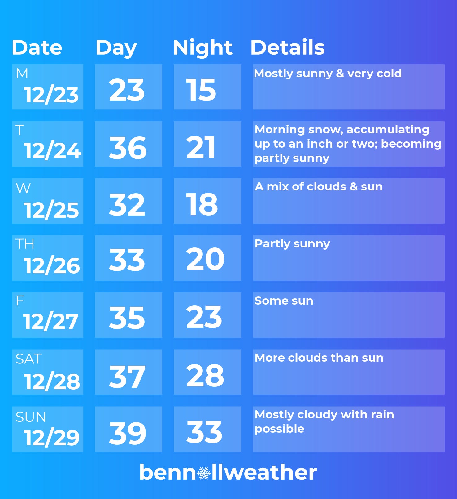
Monday: near zero degrees in the morning; sunny but very cold
Tuesday: morning snow likely, accumulating 1-2 inches
Wednesday: a tranquil Christmas
Thursday: partial sunshine, probably dry
Friday: similar to Thursday
Saturday-Sunday: not quite as cold, more clouds, chance for rain late in the weekend
🔮 What do the Hudson Valley’s snow fortunes look like in early 2025? Read on for a long-range outlook…
Happy holidays to all and may you receive the weather you wish for 🎁
Looking ahead to the week of December 30th and the New Year…
