
Fall vibes in full force
Update #676: For the first time in a long time, temperatures aren't forecast to hit 70 degrees in the Hudson Valley this week.

For the first time in a long time, there’s no 70-degree temperatures in the forecast — after Sunday. It’s a sign that fall has well and truly arrived and winter is right around the corner.
Wind-driven rain and a possible thunderstorm early Monday morning will blow around foliage. From Thursday onward, high temperatures probably won’t reach 60 degrees.
My 2025-26 Hudson Valley winter outlook, chock full of info and nice wintry photos from New Zealand, will be released next Saturday, October 25th. Premium subscribers will receive it first. You can click the button below to upgrade, which will also give you early access to details about winter storm threats. Similar to a Costco hot dog, the subscription price has not been hit by inflation and remains at $5/month or $50/year, as it has for years 🙂

The week ahead
Occasional bursts of wind and rain will be mixed with sunny days and gradually falling temperatures this week. Not too bad, overall. And the rain is needed.
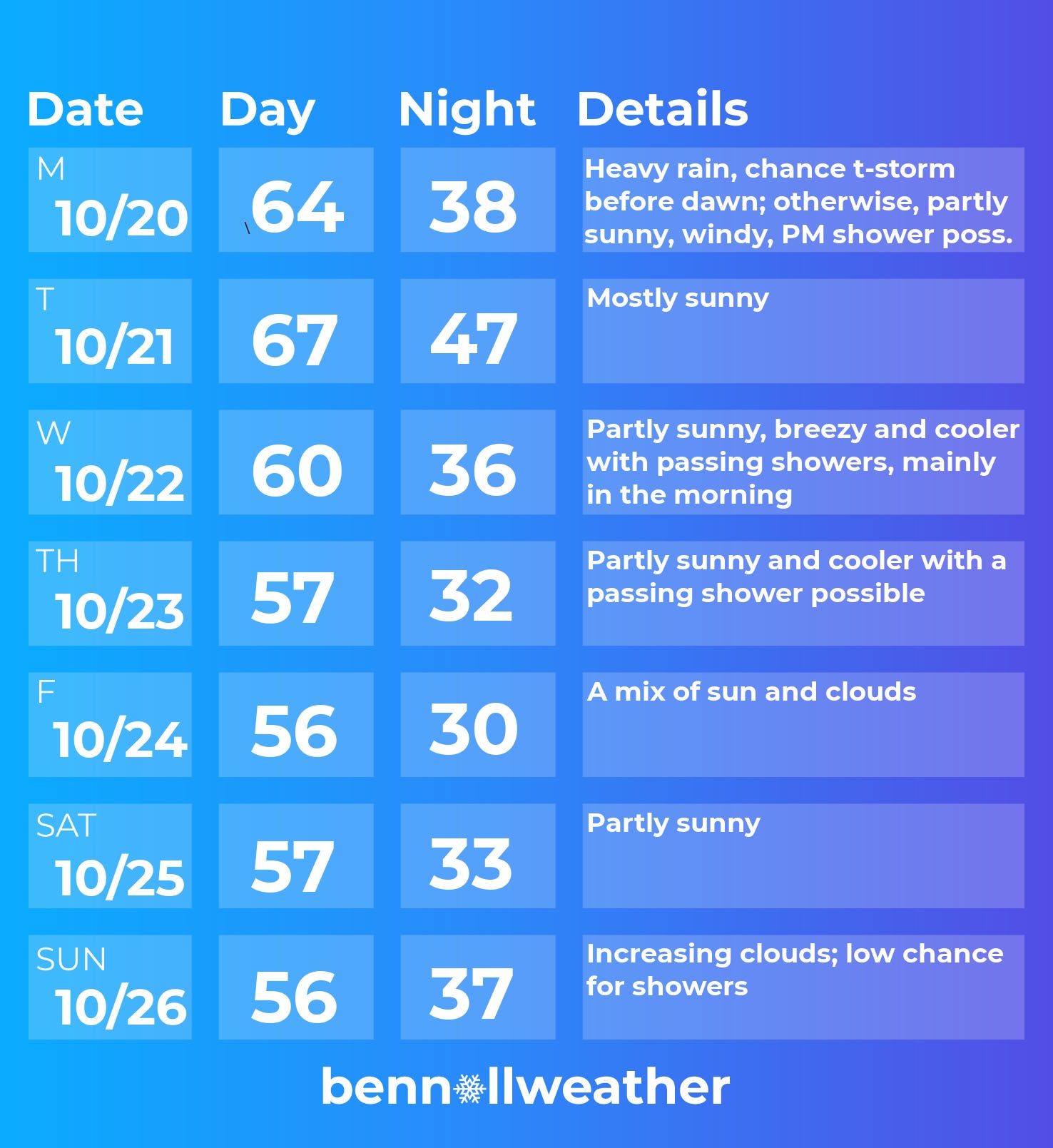
Monday: a band of heavy rain and wind will pass through the region between 4:00 and 7:00 a.m., giving way to partial sunshine with another shower chance in the afternoon
Tuesday: mostly sunny, dry, and relatively warm; rain developing at night
Wednesday: a cold front will sweep through the region, bringing a chance for showers, mainly early
Thursday: partly sunny and cool, passing shower chance
Friday: cool but dry with sun
Saturday-Sunday: the start to the weekend will probably be dry and the second half could be dry or showery, depending on where a developing storm system goes — which is currently uncertain
In the tropics, a storm may form in the Caribbean Sea this week. Although it currently looks unlikely to impact the United States in the long-term, people living in or planning to visit the islands should keep a close eye on the forecast. The next storm name will be Melissa.
Looking ahead to the week of October 27, it could turn unsettled in the Hudson Valley — partly linked to the development and track of the storm in the tropics.

See you back here next Saturday for winter outlook day! ✌️