
Update on heavy snow Friday night
Update #685d: You won’t want to be on the roads in the Hudson Valley on Friday evening as the storm arrives with tenacity.

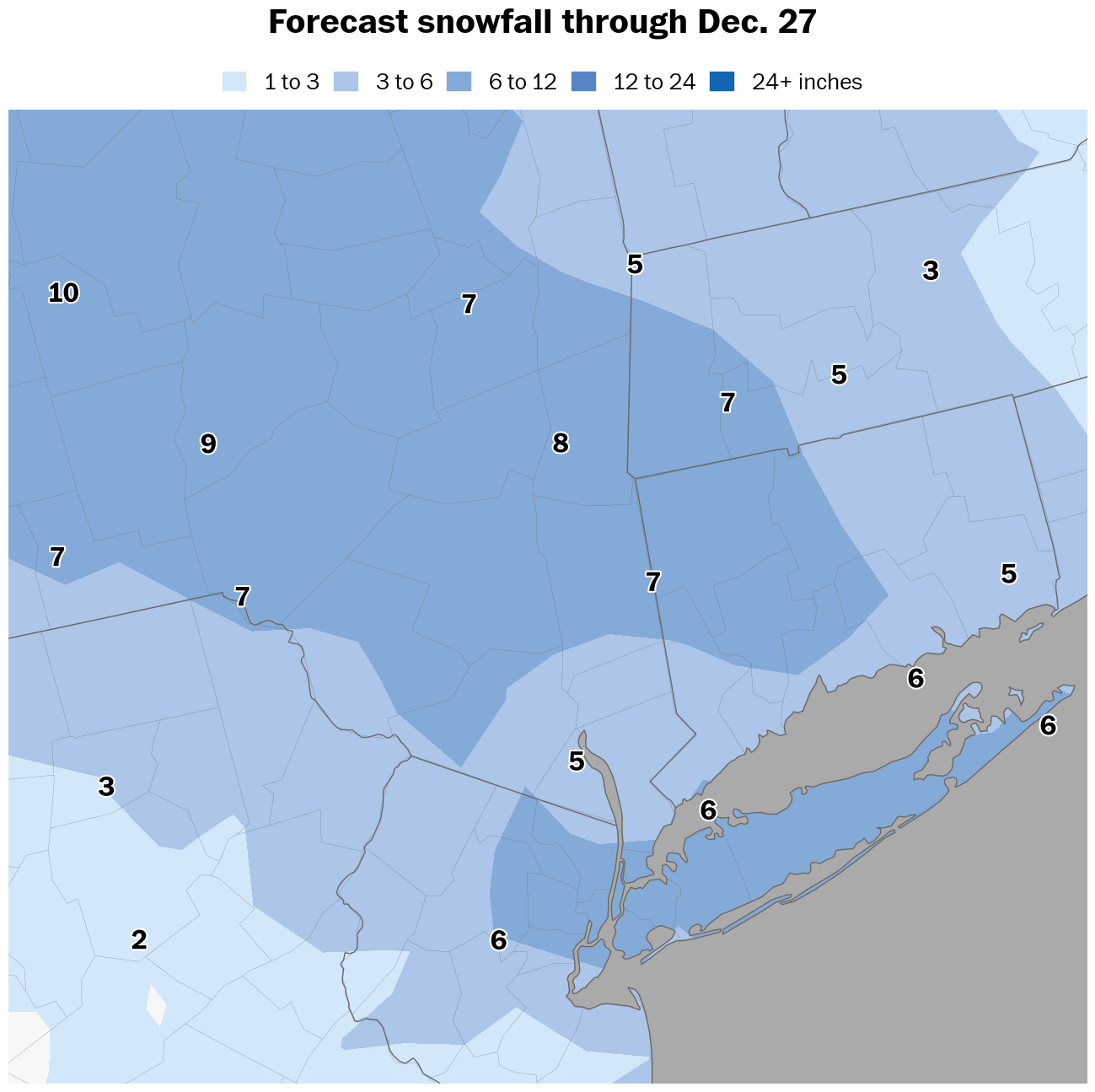
Hi again! Winter storm warnings cover the entirety of the Hudson Valley to New York City and Long Island in advance of tonight’s winter storm.
You won’t want to be on the roads on Friday evening as the storm arrives with tenacity.
Timing
Snow is expected to begin between 3 p.m. and 6 p.m. on Friday from west to east, tapering to non-accumulating flurries by 7 a.m. on Saturday before gradually ending during the morning. Snow will become moderate-to-heavy shortly after it starts on Friday evening, leading to rapidly deteriorating road conditions.
Amounts
Widespread snowfall of 5 to 10 inches is expected, with localized totals potentially reaching a foot. The highest totals are expected north of I-84 and across the Catskills in Ulster County. Snow will be fluffy and pile up easily. A band of heavy snow will probably pass through the region between 6 p.m. Friday and 12 a.m. Saturday, producing snow rates in excess of an inch per hour as well as large snowflakes that are conducive to substantial accumulation.
Impacts
Road conditions will quickly become dangerous on Friday evening as heavy snow arrives abruptly. The heaviest snow rates will occur during the first half of Friday night, making it challenging for road crews to keep up with the storm. Conditions will gradually improve on Saturday morning, though temperatures won’t rise above freezing, allowing icy spots to linger.
Confidence
As the storm closes in, forecasts shift toward trying to pinpoint areas that could see the heaviest snowfall. I’m watching the I-84 corridor and points north, including Ulster and Dutchess Counties, for the highest snow amounts. This zone may be hit by several heavy snow bands overnight. This is also where temperatures in the lower atmosphere are forecast to be coldest, allowing for dry, powdery snow that easily piles up.
This will be the last update for this storm. The next update will arrive on Sunday morning.
Freezing rain Sunday night
A dangerous period of freezing rain is possible in the Hudson Valley on Sunday, probably starting after 4 p.m. in the evening.
Because temperatures aren’t expected to rise above freezing this weekend, untreated road and sidewalk surfaces will turn to ice when rain falls on them.
Temperatures are forecast to rise above freezing on Monday, causing freezing rain to change to plain rain.
Historical events show that freezing rain tends to linger longer than forecast in the Hudson Valley, as cold air sinks into low-lying areas and takes longer than expected to get scoured out by the wind.
Stay safe!!
Let it snow!!!!!😁❄️☃️❄️☃️